You are here: Home > Network List > TA - USArray Transportable Network (new EarthScope stations) Stations List
> Station 220A Playas Peak, Playas, NM, USA > Earthquake Result Viewer
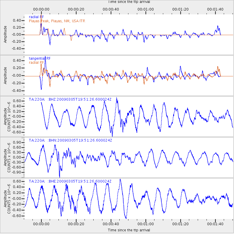
220A Playas Peak, Playas, NM, USA - Earthquake Result Viewer
*The percent match for this event was below the threshold and hence no stack was calculated.
| Earthquake location: |
North Of Svalbard |
| Earthquake latitude/longitude: |
80.3/-1.8 |
| Earthquake time(UTC): |
2009/03/05 (064) 19:41:40 GMT |
| Earthquake Depth: |
10 km |
| Earthquake Magnitude: |
5.5 MB, 5.0 MS, 5.4 MW |
| Earthquake Catalog/Contributor: |
WHDF/NEIC |
|
| Network: |
TA USArray Transportable Network (new EarthScope stations) |
| Station: |
220A Playas Peak, Playas, NM, USA |
| Lat/Lon: |
31.90 N/108.53 W |
| Elevation: |
1395 m |
|
| Distance: |
61.5 deg |
| Az: |
292.059 deg |
| Baz: |
10.667 deg |
| Ray Param: |
$rayparam |
*The percent match for this event was below the threshold and hence was not used in the summary stack. |
|
| Radial Match: |
40.473854 % |
| Radial Bump: |
395 |
| Transverse Match: |
75.50694 % |
| Transverse Bump: |
349 |
| SOD ConfigId: |
2658 |
| Insert Time: |
2010-03-06 17:32:52.461 +0000 |
| GWidth: |
2.5 |
| Max Bumps: |
400 |
| Tol: |
0.001 |
|
Signal To Noise
| Channel | StoN | STA | LTA |
| TA:220A: :BHN:20090305T19:51:26.600024Z | 3.470222 | 5.1672083E-7 | 1.4890138E-7 |
| TA:220A: :BHE:20090305T19:51:26.600024Z | 1.3788455 | 3.107294E-7 | 2.2535477E-7 |
| TA:220A: :BHZ:20090305T19:51:26.600024Z | 1.3355007 | 3.56698E-7 | 2.6708932E-7 |
| Arrivals |
| Ps | |
| PpPs | |
| PsPs/PpSs | |


