You are here: Home > Network List > TA - USArray Transportable Network (new EarthScope stations) Stations List
> Station G21K Allakaket, AK, USA > Earthquake Result Viewer
G21K Allakaket, AK, USA - Earthquake Result Viewer
*The percent match for this event was below the threshold and hence no stack was calculated.
| Earthquake location: |
Mindanao, Philippines |
| Earthquake latitude/longitude: |
7.8/123.9 |
| Earthquake time(UTC): |
2018/11/04 (308) 07:55:29 GMT |
| Earthquake Depth: |
598 km |
| Earthquake Magnitude: |
6.0 Mww |
| Earthquake Catalog/Contributor: |
NEIC PDE/us |
|
| Network: |
TA USArray Transportable Network (new EarthScope stations) |
| Station: |
G21K Allakaket, AK, USA |
| Lat/Lon: |
66.52 N/153.51 W |
| Elevation: |
446 m |
|
| Distance: |
79.9 deg |
| Az: |
23.806 deg |
| Baz: |
266.361 deg |
| Ray Param: |
$rayparam |
*The percent match for this event was below the threshold and hence was not used in the summary stack. |
|
| Radial Match: |
53.32136 % |
| Radial Bump: |
400 |
| Transverse Match: |
56.57855 % |
| Transverse Bump: |
400 |
| SOD ConfigId: |
13570011 |
| Insert Time: |
2019-05-01 17:57:37.954 +0000 |
| GWidth: |
2.5 |
| Max Bumps: |
400 |
| Tol: |
0.001 |
|
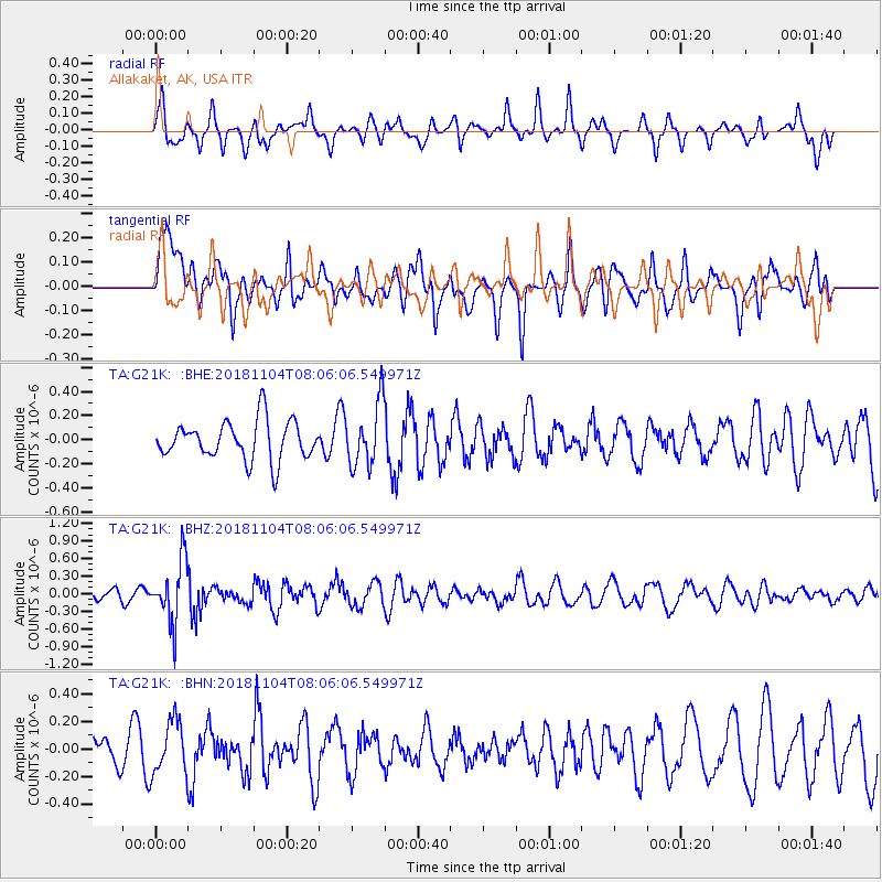
Signal To Noise
| Channel | StoN | STA | LTA |
| TA:G21K: :BHZ:20181104T08:06:06.549971Z | 4.154539 | 5.32017E-7 | 1.280568E-7 |
| TA:G21K: :BHN:20181104T08:06:06.549971Z | 1.5129827 | 1.9465845E-7 | 1.2865874E-7 |
| TA:G21K: :BHE:20181104T08:06:06.549971Z | 1.532655 | 2.4566128E-7 | 1.6028478E-7 |
| Arrivals |
| Ps | |
| PpPs | |
| PsPs/PpSs | |


