You are here: Home > Network List > TA - USArray Transportable Network (new EarthScope stations) Stations List
> Station G31M Satah River, YT, CAN > Earthquake Result Viewer
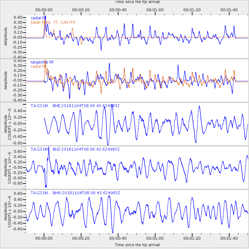
G31M Satah River, YT, CAN - Earthquake Result Viewer
*The percent match for this event was below the threshold and hence no stack was calculated.
| Earthquake location: |
Mindanao, Philippines |
| Earthquake latitude/longitude: |
7.8/123.9 |
| Earthquake time(UTC): |
2018/11/04 (308) 07:55:29 GMT |
| Earthquake Depth: |
598 km |
| Earthquake Magnitude: |
6.0 Mww |
| Earthquake Catalog/Contributor: |
NEIC PDE/us |
|
| Network: |
TA USArray Transportable Network (new EarthScope stations) |
| Station: |
G31M Satah River, YT, CAN |
| Lat/Lon: |
66.92 N/134.27 W |
| Elevation: |
61 m |
|
| Distance: |
87.5 deg |
| Az: |
22.716 deg |
| Baz: |
283.918 deg |
| Ray Param: |
$rayparam |
*The percent match for this event was below the threshold and hence was not used in the summary stack. |
|
| Radial Match: |
54.287674 % |
| Radial Bump: |
320 |
| Transverse Match: |
43.763557 % |
| Transverse Bump: |
279 |
| SOD ConfigId: |
13570011 |
| Insert Time: |
2019-05-01 17:57:40.782 +0000 |
| GWidth: |
2.5 |
| Max Bumps: |
400 |
| Tol: |
0.001 |
|
Signal To Noise
| Channel | StoN | STA | LTA |
| TA:G31M: :BHZ:20181104T08:06:43.624983Z | 1.9457976 | 3.7443195E-7 | 1.9243109E-7 |
| TA:G31M: :BHN:20181104T08:06:43.624983Z | 0.8829005 | 2.3543684E-7 | 2.6666297E-7 |
| TA:G31M: :BHE:20181104T08:06:43.624983Z | 1.7128739 | 3.7884809E-7 | 2.2117686E-7 |
| Arrivals |
| Ps | |
| PpPs | |
| PsPs/PpSs | |


