You are here: Home > Network List > TA - USArray Transportable Network (new EarthScope stations) Stations List
> Station 225A Deer Hill, Carlsbad, NM, USA > Earthquake Result Viewer
225A Deer Hill, Carlsbad, NM, USA - Earthquake Result Viewer
| Earthquake location: |
Central Mid-Atlantic Ridge |
| Earthquake latitude/longitude: |
8.1/-38.7 |
| Earthquake time(UTC): |
2008/09/10 (254) 13:08:14 GMT |
| Earthquake Depth: |
10 km |
| Earthquake Magnitude: |
6.3 MB, 6.5 MS, 6.6 MW, 6.6 MW |
| Earthquake Catalog/Contributor: |
WHDF/NEIC |
|
| Network: |
TA USArray Transportable Network (new EarthScope stations) |
| Station: |
225A Deer Hill, Carlsbad, NM, USA |
| Lat/Lon: |
32.11 N/104.82 W |
| Elevation: |
1703 m |
|
| Distance: |
65.5 deg |
| Az: |
301.514 deg |
| Baz: |
95.896 deg |
| Ray Param: |
0.05821673 |
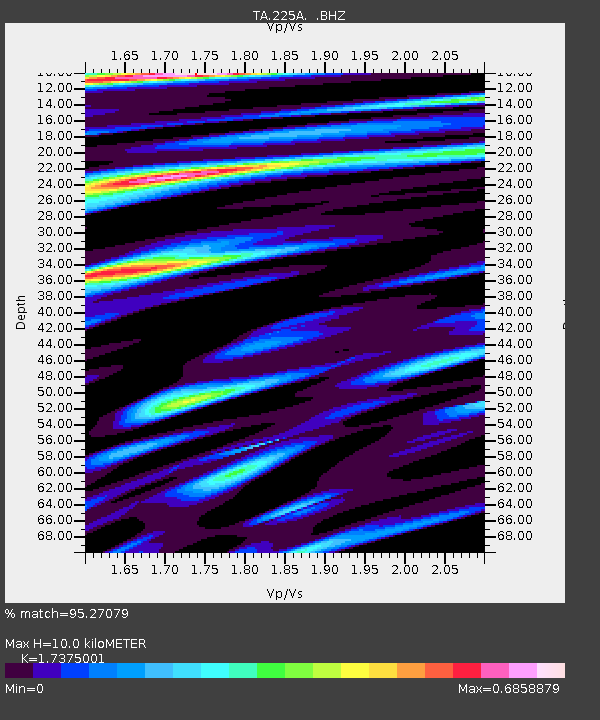
| Estimated Moho Depth: |
10.0 km |
| Estimated Crust Vp/Vs: |
1.74 |
| Assumed Crust Vp: |
6.232 km/s |
| Estimated Crust Vs: |
3.587 km/s |
| Estimated Crust Poisson's Ratio: |
0.25 |
|
| Radial Match: |
95.27079 % |
| Radial Bump: |
400 |
| Transverse Match: |
82.51993 % |
| Transverse Bump: |
400 |
| SOD ConfigId: |
2560 |
| Insert Time: |
2010-03-06 17:33:57.682 +0000 |
| GWidth: |
2.5 |
| Max Bumps: |
400 |
| Tol: |
0.001 |
|

Signal To Noise
| Channel | StoN | STA | LTA |
| TA:225A: :BHZ:20080910T13:18:27.175015Z | 2.9263299 | 3.9144535E-7 | 1.3376665E-7 |
| TA:225A: :BHN:20080910T13:18:27.175015Z | 1.0745419 | 9.4267676E-8 | 8.7728246E-8 |
| TA:225A: :BHE:20080910T13:18:27.175015Z | 2.3452125 | 1.6654099E-7 | 7.101317E-8 |
| Arrivals |
| Ps | 1.2 SECOND |
| PpPs | 4.2 SECOND |
| PsPs/PpSs | 5.5 SECOND |


