You are here: Home > Network List > TA - USArray Transportable Network (new EarthScope stations) Stations List
> Station 225A Deer Hill, Carlsbad, NM, USA > Earthquake Result Viewer
225A Deer Hill, Carlsbad, NM, USA - Earthquake Result Viewer
| Earthquake location: |
Sea Of Okhotsk |
| Earthquake latitude/longitude: |
54.2/154.3 |
| Earthquake time(UTC): |
2008/11/24 (329) 09:02:58 GMT |
| Earthquake Depth: |
492 km |
| Earthquake Magnitude: |
6.5 MB, 7.3 MW, 7.3 MW |
| Earthquake Catalog/Contributor: |
WHDF/NEIC |
|
| Network: |
TA USArray Transportable Network (new EarthScope stations) |
| Station: |
225A Deer Hill, Carlsbad, NM, USA |
| Lat/Lon: |
32.11 N/104.82 W |
| Elevation: |
1703 m |
|
| Distance: |
70.5 deg |
| Az: |
62.163 deg |
| Baz: |
322.253 deg |
| Ray Param: |
0.05334558 |
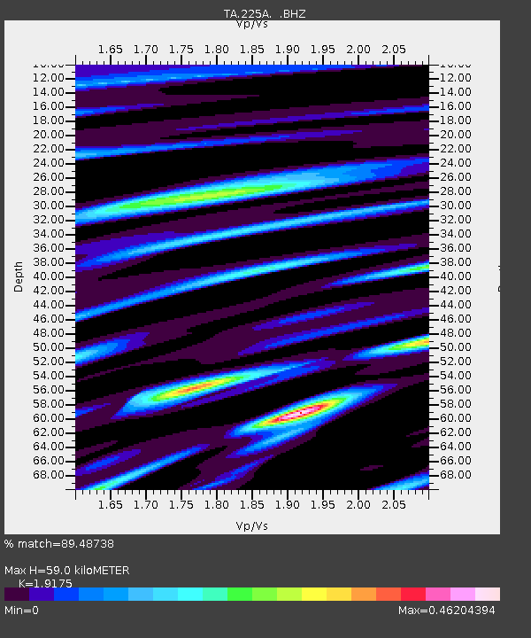
| Estimated Moho Depth: |
59.0 km |
| Estimated Crust Vp/Vs: |
1.92 |
| Assumed Crust Vp: |
6.232 km/s |
| Estimated Crust Vs: |
3.25 km/s |
| Estimated Crust Poisson's Ratio: |
0.31 |
|
| Radial Match: |
89.48738 % |
| Radial Bump: |
279 |
| Transverse Match: |
69.21252 % |
| Transverse Bump: |
400 |
| SOD ConfigId: |
2658 |
| Insert Time: |
2010-03-06 17:34:32.460 +0000 |
| GWidth: |
2.5 |
| Max Bumps: |
400 |
| Tol: |
0.001 |
|
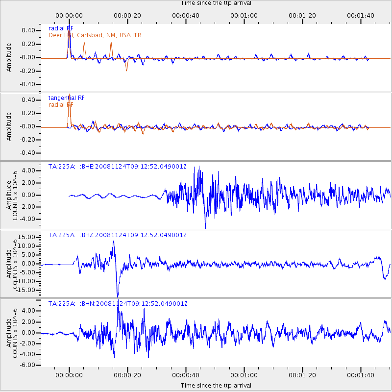
Signal To Noise
| Channel | StoN | STA | LTA |
| TA:225A: :BHZ:20081124T09:12:52.049001Z | 7.6736116 | 2.0837829E-6 | 2.7155178E-7 |
| TA:225A: :BHN:20081124T09:12:52.049001Z | 3.1900737 | 5.7872694E-7 | 1.8141492E-7 |
| TA:225A: :BHE:20081124T09:12:52.049001Z | 2.792698 | 5.14571E-7 | 1.842559E-7 |
| Arrivals |
| Ps | 9.0 SECOND |
| PpPs | 27 SECOND |
| PsPs/PpSs | 36 SECOND |


