You are here: Home > Network List > TS - TERRAscope (Southern California Seismic Network) Stations List
> Station BAR Barrett Dam, California, USA > Earthquake Result Viewer
BAR Barrett Dam, California, USA - Earthquake Result Viewer
*The percent match for this event was below the threshold and hence no stack was calculated.
| Earthquake location: |
South Of Fiji Islands |
| Earthquake latitude/longitude: |
-24.6/-177.3 |
| Earthquake time(UTC): |
1995/06/23 (174) 16:10:56 GMT |
| Earthquake Depth: |
108 km |
| Earthquake Magnitude: |
5.8 UNKNOWN, 5.4 MB |
| Earthquake Catalog/Contributor: |
WHDF/NEIC |
|
| Network: |
TS TERRAscope (Southern California Seismic Network) |
| Station: |
BAR Barrett Dam, California, USA |
| Lat/Lon: |
32.68 N/116.67 W |
| Elevation: |
548 m |
|
| Distance: |
81.1 deg |
| Az: |
48.049 deg |
| Baz: |
233.409 deg |
| Ray Param: |
$rayparam |
*The percent match for this event was below the threshold and hence was not used in the summary stack. |
|
| Radial Match: |
61.407608 % |
| Radial Bump: |
400 |
| Transverse Match: |
55.666183 % |
| Transverse Bump: |
400 |
| SOD ConfigId: |
4480 |
| Insert Time: |
2010-02-26 14:00:03.565 +0000 |
| GWidth: |
2.5 |
| Max Bumps: |
400 |
| Tol: |
0.001 |
|
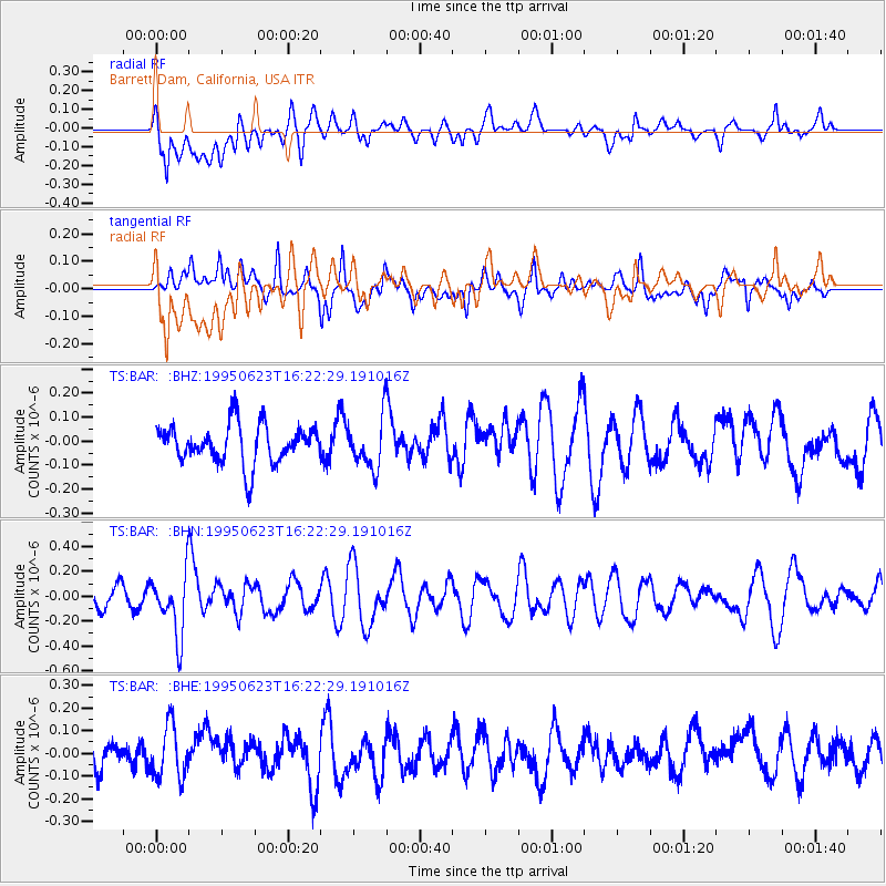
Signal To Noise
| Channel | StoN | STA | LTA |
| TS:BAR: :BHN:19950623T16:22:29.191016Z | 2.689514 | 2.5279155E-7 | 9.399153E-8 |
| TS:BAR: :BHE:19950623T16:22:29.191016Z | 1.7551175 | 1.1955692E-7 | 6.811904E-8 |
| TS:BAR: :BHZ:19950623T16:22:29.191016Z | 1.2587078 | 1.02691324E-7 | 8.158473E-8 |
| Arrivals |
| Ps | |
| PpPs | |
| PsPs/PpSs | |


