You are here: Home > Network List > TA - USArray Transportable Network (new EarthScope stations) Stations List
> Station 225A Deer Hill, Carlsbad, NM, USA > Earthquake Result Viewer
225A Deer Hill, Carlsbad, NM, USA - Earthquake Result Viewer
| Earthquake location: |
North Of Svalbard |
| Earthquake latitude/longitude: |
80.3/-1.9 |
| Earthquake time(UTC): |
2009/03/06 (065) 10:50:29 GMT |
| Earthquake Depth: |
9.0 km |
| Earthquake Magnitude: |
6.6 MB, 6.5 MS, 6.5 MW, 6.4 MW |
| Earthquake Catalog/Contributor: |
WHDF/NEIC |
|
| Network: |
TA USArray Transportable Network (new EarthScope stations) |
| Station: |
225A Deer Hill, Carlsbad, NM, USA |
| Lat/Lon: |
32.11 N/104.82 W |
| Elevation: |
1703 m |
|
| Distance: |
60.7 deg |
| Az: |
288.532 deg |
| Baz: |
10.895 deg |
| Ray Param: |
0.06135097 |
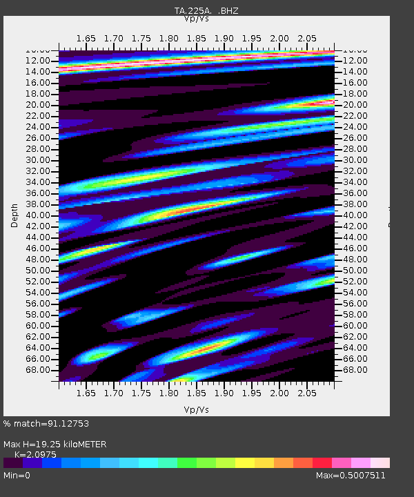
| Estimated Moho Depth: |
19.25 km |
| Estimated Crust Vp/Vs: |
2.10 |
| Assumed Crust Vp: |
6.232 km/s |
| Estimated Crust Vs: |
2.971 km/s |
| Estimated Crust Poisson's Ratio: |
0.35 |
|
| Radial Match: |
91.12753 % |
| Radial Bump: |
400 |
| Transverse Match: |
81.15124 % |
| Transverse Bump: |
400 |
| SOD ConfigId: |
2658 |
| Insert Time: |
2010-03-06 17:34:33.838 +0000 |
| GWidth: |
2.5 |
| Max Bumps: |
400 |
| Tol: |
0.001 |
|
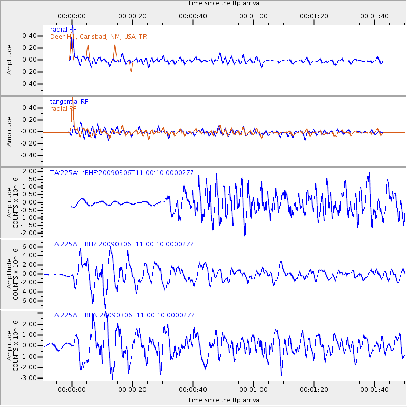
Signal To Noise
| Channel | StoN | STA | LTA |
| TA:225A: :BHZ:20090306T11:00:10.000027Z | 12.341435 | 2.4577637E-6 | 1.9914732E-7 |
| TA:225A: :BHN:20090306T11:00:10.000027Z | 7.2922525 | 1.1666361E-6 | 1.5998296E-7 |
| TA:225A: :BHE:20090306T11:00:10.000027Z | 3.508567 | 4.0569967E-7 | 1.1563115E-7 |
| Arrivals |
| Ps | 3.5 SECOND |
| PpPs | 9.2 SECOND |
| PsPs/PpSs | 13 SECOND |


