You are here: Home > Network List > TA - USArray Transportable Network (new EarthScope stations) Stations List
> Station 225A Deer Hill, Carlsbad, NM, USA > Earthquake Result Viewer
225A Deer Hill, Carlsbad, NM, USA - Earthquake Result Viewer
| Earthquake location: |
Kodiak Island Region, Alaska |
| Earthquake latitude/longitude: |
56.5/-152.7 |
| Earthquake time(UTC): |
2009/03/30 (089) 07:13:07 GMT |
| Earthquake Depth: |
21 km |
| Earthquake Magnitude: |
5.9 MB, 5.9 MS, 5.9 MW, 5.9 MW |
| Earthquake Catalog/Contributor: |
WHDF/NEIC |
|
| Network: |
TA USArray Transportable Network (new EarthScope stations) |
| Station: |
225A Deer Hill, Carlsbad, NM, USA |
| Lat/Lon: |
32.11 N/104.82 W |
| Elevation: |
1703 m |
|
| Distance: |
40.9 deg |
| Az: |
105.995 deg |
| Baz: |
321.144 deg |
| Ray Param: |
0.07407446 |
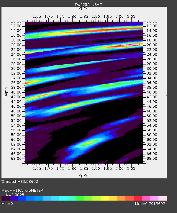
| Estimated Moho Depth: |
19.5 km |
| Estimated Crust Vp/Vs: |
2.08 |
| Assumed Crust Vp: |
6.232 km/s |
| Estimated Crust Vs: |
2.992 km/s |
| Estimated Crust Poisson's Ratio: |
0.35 |
|
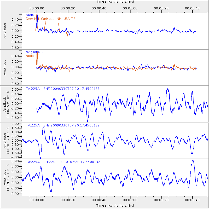
| Radial Match: |
83.98662 % |
| Radial Bump: |
306 |
| Transverse Match: |
62.553703 % |
| Transverse Bump: |
400 |
| SOD ConfigId: |
2658 |
| Insert Time: |
2010-03-06 17:34:39.853 +0000 |
| GWidth: |
2.5 |
| Max Bumps: |
400 |
| Tol: |
0.001 |
|
Signal To Noise
| Channel | StoN | STA | LTA |
| TA:225A: :BHZ:20090330T07:20:17.450013Z | 9.8401375 | 1.1391394E-6 | 1.1576459E-7 |
| TA:225A: :BHN:20090330T07:20:17.450013Z | 3.357612 | 3.316143E-7 | 9.876493E-8 |
| TA:225A: :BHE:20090330T07:20:17.450013Z | 1.7638165 | 3.3137576E-7 | 1.8787429E-7 |
| Arrivals |
| Ps | 3.6 SECOND |
| PpPs | 9.1 SECOND |
| PsPs/PpSs | 13 SECOND |


