You are here: Home > Network List > TA - USArray Transportable Network (new EarthScope stations) Stations List
> Station 225A Deer Hill, Carlsbad, NM, USA > Earthquake Result Viewer
225A Deer Hill, Carlsbad, NM, USA - Earthquake Result Viewer
| Earthquake location: |
Kuril Islands |
| Earthquake latitude/longitude: |
46.0/151.5 |
| Earthquake time(UTC): |
2009/04/07 (097) 04:23:33 GMT |
| Earthquake Depth: |
31 km |
| Earthquake Magnitude: |
6.5 MB, 6.8 MS, 6.9 MW, 6.9 MW |
| Earthquake Catalog/Contributor: |
WHDF/NEIC |
|
| Network: |
TA USArray Transportable Network (new EarthScope stations) |
| Station: |
225A Deer Hill, Carlsbad, NM, USA |
| Lat/Lon: |
32.11 N/104.82 W |
| Elevation: |
1703 m |
|
| Distance: |
76.1 deg |
| Az: |
58.172 deg |
| Baz: |
315.791 deg |
| Ray Param: |
0.051183097 |
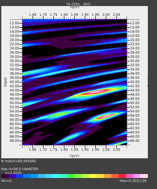
| Estimated Moho Depth: |
56.0 km |
| Estimated Crust Vp/Vs: |
2.00 |
| Assumed Crust Vp: |
6.232 km/s |
| Estimated Crust Vs: |
3.112 km/s |
| Estimated Crust Poisson's Ratio: |
0.33 |
|
| Radial Match: |
95.945595 % |
| Radial Bump: |
400 |
| Transverse Match: |
87.41051 % |
| Transverse Bump: |
400 |
| SOD ConfigId: |
2658 |
| Insert Time: |
2010-03-06 17:34:44.000 +0000 |
| GWidth: |
2.5 |
| Max Bumps: |
400 |
| Tol: |
0.001 |
|
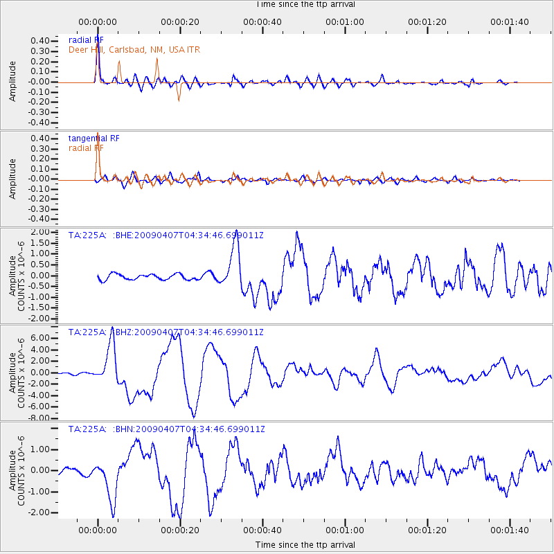
Signal To Noise
| Channel | StoN | STA | LTA |
| TA:225A: :BHZ:20090407T04:34:46.699011Z | 23.48038 | 3.6611796E-6 | 1.5592506E-7 |
| TA:225A: :BHN:20090407T04:34:46.699011Z | 10.096056 | 9.992805E-7 | 9.89773E-8 |
| TA:225A: :BHE:20090407T04:34:46.699011Z | 7.910671 | 1.0211224E-6 | 1.2908164E-7 |
| Arrivals |
| Ps | 9.2 SECOND |
| PpPs | 26 SECOND |
| PsPs/PpSs | 36 SECOND |


