You are here: Home > Network List > TA - USArray Transportable Network (new EarthScope stations) Stations List
> Station 225A Deer Hill, Carlsbad, NM, USA > Earthquake Result Viewer
225A Deer Hill, Carlsbad, NM, USA - Earthquake Result Viewer
| Earthquake location: |
Loyalty Islands |
| Earthquake latitude/longitude: |
-20.1/168.9 |
| Earthquake time(UTC): |
2008/04/09 (100) 12:46:12 GMT |
| Earthquake Depth: |
33 km |
| Earthquake Magnitude: |
6.3 MB, 7.3 MS, 7.3 MW, 7.3 MW |
| Earthquake Catalog/Contributor: |
WHDF/NEIC |
|
| Network: |
TA USArray Transportable Network (new EarthScope stations) |
| Station: |
225A Deer Hill, Carlsbad, NM, USA |
| Lat/Lon: |
32.11 N/104.82 W |
| Elevation: |
1703 m |
|
| Distance: |
97.4 deg |
| Az: |
58.645 deg |
| Baz: |
251.069 deg |
| Ray Param: |
0.040209785 |
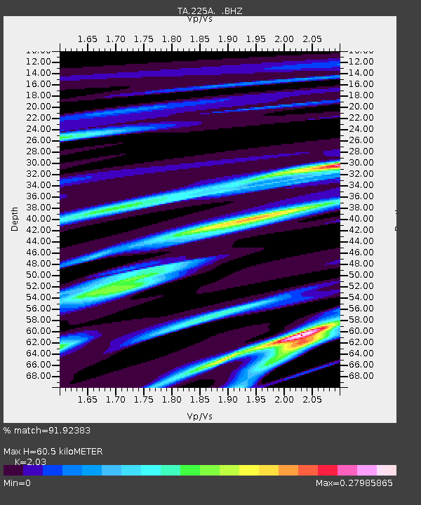
| Estimated Moho Depth: |
60.5 km |
| Estimated Crust Vp/Vs: |
2.03 |
| Assumed Crust Vp: |
6.232 km/s |
| Estimated Crust Vs: |
3.07 km/s |
| Estimated Crust Poisson's Ratio: |
0.34 |
|
| Radial Match: |
91.92383 % |
| Radial Bump: |
175 |
| Transverse Match: |
63.697746 % |
| Transverse Bump: |
357 |
| SOD ConfigId: |
2504 |
| Insert Time: |
2010-03-06 17:34:48.684 +0000 |
| GWidth: |
2.5 |
| Max Bumps: |
400 |
| Tol: |
0.001 |
|
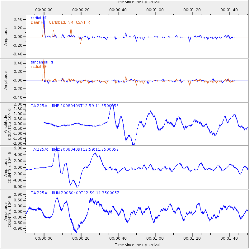
Signal To Noise
| Channel | StoN | STA | LTA |
| TA:225A: :BHZ:20080409T12:59:11.350005Z | 1.7884518 | 5.248137E-7 | 2.934458E-7 |
| TA:225A: :BHN:20080409T12:59:11.350005Z | 1.460422 | 2.4053202E-7 | 1.6470035E-7 |
| TA:225A: :BHE:20080409T12:59:11.350005Z | 1.9197913 | 2.0699528E-7 | 1.0782176E-7 |
| Arrivals |
| Ps | 10 SECOND |
| PpPs | 29 SECOND |
| PsPs/PpSs | 39 SECOND |


