You are here: Home > Network List > NN - Western Great Basin/Eastern Sierra Nevada Stations List
> Station CMK6 Chalk Mountain, Churchill County, NV, USA > Earthquake Result Viewer
CMK6 Chalk Mountain, Churchill County, NV, USA - Earthquake Result Viewer
| Earthquake location: |
Hokkaido, Japan Region |
| Earthquake latitude/longitude: |
44.6/145.6 |
| Earthquake time(UTC): |
2018/11/04 (308) 19:26:03 GMT |
| Earthquake Depth: |
8.0 km |
| Earthquake Magnitude: |
5.9 Mww |
| Earthquake Catalog/Contributor: |
NEIC PDE/us |
|
| Network: |
NN Western Great Basin/Eastern Sierra Nevada |
| Station: |
CMK6 Chalk Mountain, Churchill County, NV, USA |
| Lat/Lon: |
39.31 N/118.12 W |
| Elevation: |
1332 m |
|
| Distance: |
67.6 deg |
| Az: |
56.498 deg |
| Baz: |
309.797 deg |
| Ray Param: |
0.056832563 |
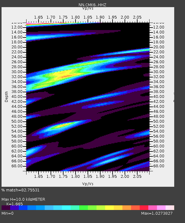
| Estimated Moho Depth: |
10.0 km |
| Estimated Crust Vp/Vs: |
1.66 |
| Assumed Crust Vp: |
6.279 km/s |
| Estimated Crust Vs: |
3.771 km/s |
| Estimated Crust Poisson's Ratio: |
0.22 |
|
| Radial Match: |
82.75531 % |
| Radial Bump: |
400 |
| Transverse Match: |
77.083145 % |
| Transverse Bump: |
400 |
| SOD ConfigId: |
13570011 |
| Insert Time: |
2019-05-01 18:08:41.371 +0000 |
| GWidth: |
2.5 |
| Max Bumps: |
400 |
| Tol: |
0.001 |
|

Signal To Noise
| Channel | StoN | STA | LTA |
| NN:CMK6: :HHZ:20181104T19:36:29.144978Z | 18.63006 | 8.3550674E-7 | 4.4847237E-8 |
| NN:CMK6: :HHN:20181104T19:36:29.144978Z | 3.32201 | 1.6178399E-7 | 4.870063E-8 |
| NN:CMK6: :HHE:20181104T19:36:29.144978Z | 4.343127 | 1.9090282E-7 | 4.3955154E-8 |
| Arrivals |
| Ps | 1.1 SECOND |
| PpPs | 4.1 SECOND |
| PsPs/PpSs | 5.2 SECOND |


