You are here: Home > Network List > NN - Western Great Basin/Eastern Sierra Nevada Stations List
> Station SHP Sheep Range, Nevada w84gm > Earthquake Result Viewer
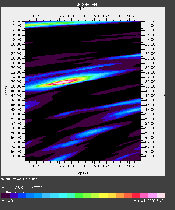
SHP Sheep Range, Nevada w84gm - Earthquake Result Viewer
| Earthquake location: |
Hokkaido, Japan Region |
| Earthquake latitude/longitude: |
44.6/145.6 |
| Earthquake time(UTC): |
2018/11/04 (308) 19:26:03 GMT |
| Earthquake Depth: |
8.0 km |
| Earthquake Magnitude: |
5.9 Mww |
| Earthquake Catalog/Contributor: |
NEIC PDE/us |
|
| Network: |
NN Western Great Basin/Eastern Sierra Nevada |
| Station: |
SHP Sheep Range, Nevada w84gm |
| Lat/Lon: |
36.50 N/115.16 W |
| Elevation: |
1632 m |
|
| Distance: |
71.2 deg |
| Az: |
57.126 deg |
| Baz: |
311.831 deg |
| Ray Param: |
0.054462202 |
| Estimated Moho Depth: |
36.0 km |
| Estimated Crust Vp/Vs: |
1.76 |
| Assumed Crust Vp: |
6.276 km/s |
| Estimated Crust Vs: |
3.561 km/s |
| Estimated Crust Poisson's Ratio: |
0.26 |
|
| Radial Match: |
91.95065 % |
| Radial Bump: |
400 |
| Transverse Match: |
76.80117 % |
| Transverse Bump: |
400 |
| SOD ConfigId: |
13570011 |
| Insert Time: |
2019-05-01 18:08:56.151 +0000 |
| GWidth: |
2.5 |
| Max Bumps: |
400 |
| Tol: |
0.001 |
|

Signal To Noise
| Channel | StoN | STA | LTA |
| NN:SHP: :HHZ:20181104T19:36:51.380024Z | 22.226955 | 7.9937536E-7 | 3.5964234E-8 |
| NN:SHP: :HHN:20181104T19:36:51.380024Z | 5.9572306 | 2.773068E-7 | 4.654962E-8 |
| NN:SHP: :HHE:20181104T19:36:51.380024Z | 2.1074731 | 1.4373862E-7 | 6.820425E-8 |
| Arrivals |
| Ps | 4.5 SECOND |
| PpPs | 15 SECOND |
| PsPs/PpSs | 20 SECOND |


