You are here: Home > Network List > TA - USArray Transportable Network (new EarthScope stations) Stations List
> Station 225A Deer Hill, Carlsbad, NM, USA > Earthquake Result Viewer
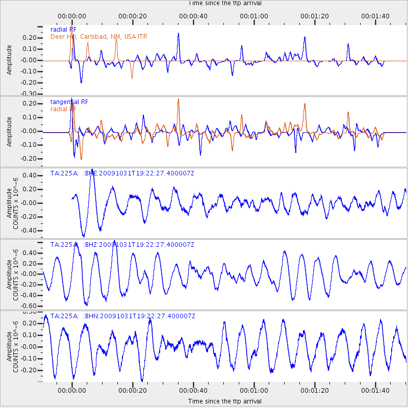
225A Deer Hill, Carlsbad, NM, USA - Earthquake Result Viewer
*The percent match for this event was below the threshold and hence no stack was calculated.
| Earthquake location: |
Santa Cruz Islands |
| Earthquake latitude/longitude: |
-11.4/166.4 |
| Earthquake time(UTC): |
2009/10/31 (304) 19:09:51 GMT |
| Earthquake Depth: |
134 km |
| Earthquake Magnitude: |
5.9 MB, 5.9 MW, 5.9 MW |
| Earthquake Catalog/Contributor: |
WHDF/NEIC |
|
| Network: |
TA USArray Transportable Network (new EarthScope stations) |
| Station: |
225A Deer Hill, Carlsbad, NM, USA |
| Lat/Lon: |
32.11 N/104.82 W |
| Elevation: |
1703 m |
|
| Distance: |
94.9 deg |
| Az: |
58.388 deg |
| Baz: |
259.757 deg |
| Ray Param: |
$rayparam |
*The percent match for this event was below the threshold and hence was not used in the summary stack. |
|
| Radial Match: |
51.244213 % |
| Radial Bump: |
390 |
| Transverse Match: |
58.954834 % |
| Transverse Bump: |
400 |
| SOD ConfigId: |
2622 |
| Insert Time: |
2010-03-06 17:35:56.061 +0000 |
| GWidth: |
2.5 |
| Max Bumps: |
400 |
| Tol: |
0.001 |
|
Signal To Noise
| Channel | StoN | STA | LTA |
| TA:225A: :BHZ:20091031T19:22:27.400007Z | 1.5797077 | 4.1153456E-7 | 2.6051308E-7 |
| TA:225A: :BHN:20091031T19:22:27.400007Z | 1.0794594 | 1.5589845E-7 | 1.444227E-7 |
| TA:225A: :BHE:20091031T19:22:27.400007Z | 0.6119654 | 1.3071961E-7 | 2.1360621E-7 |
| Arrivals |
| Ps | |
| PpPs | |
| PsPs/PpSs | |


