You are here: Home > Network List > TA - USArray Transportable Network (new EarthScope stations) Stations List
> Station F26K Sheenjek River, AK, USA > Earthquake Result Viewer
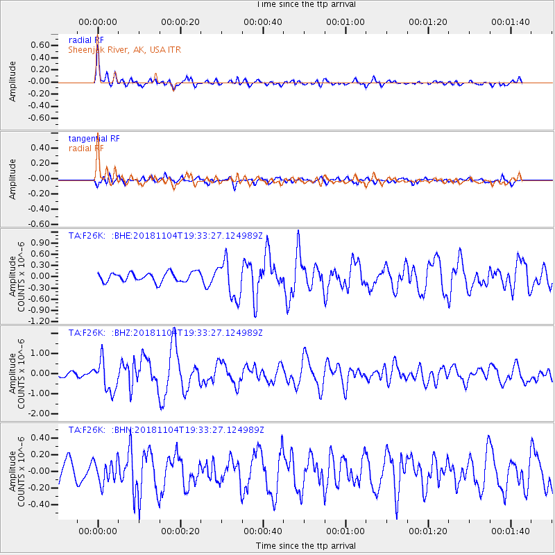
F26K Sheenjek River, AK, USA - Earthquake Result Viewer
*The percent match for this event was below the threshold and hence no stack was calculated.
| Earthquake location: |
Hokkaido, Japan Region |
| Earthquake latitude/longitude: |
44.6/145.6 |
| Earthquake time(UTC): |
2018/11/04 (308) 19:26:03 GMT |
| Earthquake Depth: |
8.0 km |
| Earthquake Magnitude: |
5.9 Mww |
| Earthquake Catalog/Contributor: |
NEIC PDE/us |
|
| Network: |
TA USArray Transportable Network (new EarthScope stations) |
| Station: |
F26K Sheenjek River, AK, USA |
| Lat/Lon: |
67.69 N/144.15 W |
| Elevation: |
683 m |
|
| Distance: |
42.4 deg |
| Az: |
32.201 deg |
| Baz: |
273.725 deg |
| Ray Param: |
$rayparam |
*The percent match for this event was below the threshold and hence was not used in the summary stack. |
|
| Radial Match: |
75.78525 % |
| Radial Bump: |
400 |
| Transverse Match: |
54.05753 % |
| Transverse Bump: |
400 |
| SOD ConfigId: |
13570011 |
| Insert Time: |
2019-05-01 18:11:52.879 +0000 |
| GWidth: |
2.5 |
| Max Bumps: |
400 |
| Tol: |
0.001 |
|
Signal To Noise
| Channel | StoN | STA | LTA |
| TA:F26K: :BHZ:20181104T19:33:27.124989Z | 5.6688023 | 7.8730255E-7 | 1.3888341E-7 |
| TA:F26K: :BHN:20181104T19:33:27.124989Z | 0.925026 | 1.3000869E-7 | 1.4054598E-7 |
| TA:F26K: :BHE:20181104T19:33:27.124989Z | 4.1953673 | 5.148288E-7 | 1.2271363E-7 |
| Arrivals |
| Ps | |
| PpPs | |
| PsPs/PpSs | |


