You are here: Home > Network List > TA - USArray Transportable Network (new EarthScope stations) Stations List
> Station G18K Tagagawik, AK, USA > Earthquake Result Viewer
G18K Tagagawik, AK, USA - Earthquake Result Viewer
| Earthquake location: |
Hokkaido, Japan Region |
| Earthquake latitude/longitude: |
44.6/145.6 |
| Earthquake time(UTC): |
2018/11/04 (308) 19:26:03 GMT |
| Earthquake Depth: |
8.0 km |
| Earthquake Magnitude: |
5.9 Mww |
| Earthquake Catalog/Contributor: |
NEIC PDE/us |
|
| Network: |
TA USArray Transportable Network (new EarthScope stations) |
| Station: |
G18K Tagagawik, AK, USA |
| Lat/Lon: |
65.89 N/158.65 W |
| Elevation: |
484 m |
|
| Distance: |
36.6 deg |
| Az: |
34.709 deg |
| Baz: |
262.329 deg |
| Ray Param: |
0.07659781 |
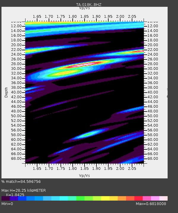
| Estimated Moho Depth: |
28.25 km |
| Estimated Crust Vp/Vs: |
1.84 |
| Assumed Crust Vp: |
6.1 km/s |
| Estimated Crust Vs: |
3.311 km/s |
| Estimated Crust Poisson's Ratio: |
0.29 |
|
| Radial Match: |
84.596756 % |
| Radial Bump: |
400 |
| Transverse Match: |
59.3147 % |
| Transverse Bump: |
400 |
| SOD ConfigId: |
13570011 |
| Insert Time: |
2019-05-01 18:11:57.715 +0000 |
| GWidth: |
2.5 |
| Max Bumps: |
400 |
| Tol: |
0.001 |
|

Signal To Noise
| Channel | StoN | STA | LTA |
| TA:G18K: :BHZ:20181104T19:32:38.849995Z | 7.765457 | 9.3977445E-7 | 1.2101985E-7 |
| TA:G18K: :BHN:20181104T19:32:38.849995Z | 0.81776166 | 1.1469811E-7 | 1.402586E-7 |
| TA:G18K: :BHE:20181104T19:32:38.849995Z | 5.1333876 | 5.4672506E-7 | 1.0650376E-7 |
| Arrivals |
| Ps | 4.2 SECOND |
| PpPs | 12 SECOND |
| PsPs/PpSs | 17 SECOND |


