You are here: Home > Network List > TA - USArray Transportable Network (new EarthScope stations) Stations List
> Station G21K Allakaket, AK, USA > Earthquake Result Viewer
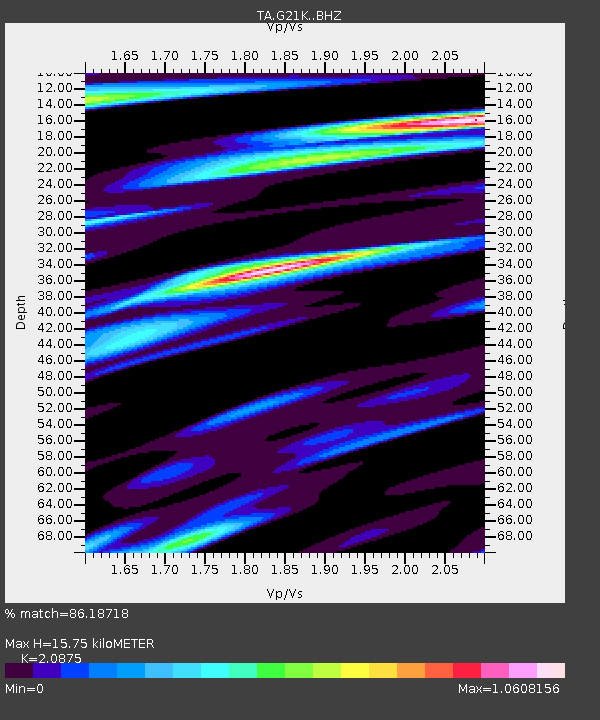
G21K Allakaket, AK, USA - Earthquake Result Viewer
| Earthquake location: |
Hokkaido, Japan Region |
| Earthquake latitude/longitude: |
44.6/145.6 |
| Earthquake time(UTC): |
2018/11/04 (308) 19:26:03 GMT |
| Earthquake Depth: |
8.0 km |
| Earthquake Magnitude: |
5.9 Mww |
| Earthquake Catalog/Contributor: |
NEIC PDE/us |
|
| Network: |
TA USArray Transportable Network (new EarthScope stations) |
| Station: |
G21K Allakaket, AK, USA |
| Lat/Lon: |
66.52 N/153.51 W |
| Elevation: |
446 m |
|
| Distance: |
38.7 deg |
| Az: |
34.028 deg |
| Baz: |
266.496 deg |
| Ray Param: |
0.07539368 |
| Estimated Moho Depth: |
15.75 km |
| Estimated Crust Vp/Vs: |
2.09 |
| Assumed Crust Vp: |
6.455 km/s |
| Estimated Crust Vs: |
3.092 km/s |
| Estimated Crust Poisson's Ratio: |
0.35 |
|
| Radial Match: |
86.18718 % |
| Radial Bump: |
369 |
| Transverse Match: |
70.3076 % |
| Transverse Bump: |
400 |
| SOD ConfigId: |
13570011 |
| Insert Time: |
2019-05-01 18:11:59.974 +0000 |
| GWidth: |
2.5 |
| Max Bumps: |
400 |
| Tol: |
0.001 |
|

Signal To Noise
| Channel | StoN | STA | LTA |
| TA:G21K: :BHZ:20181104T19:32:56.925007Z | 6.1428337 | 9.546682E-7 | 1.554117E-7 |
| TA:G21K: :BHN:20181104T19:32:56.925007Z | 1.5729594 | 2.0503639E-7 | 1.3035071E-7 |
| TA:G21K: :BHE:20181104T19:32:56.925007Z | 3.0368447 | 6.5513086E-7 | 2.1572748E-7 |
| Arrivals |
| Ps | 2.8 SECOND |
| PpPs | 7.1 SECOND |
| PsPs/PpSs | 9.9 SECOND |


