You are here: Home > Network List > TA - USArray Transportable Network (new EarthScope stations) Stations List
> Station H31M Peel River, Yukon, CAN > Earthquake Result Viewer
H31M Peel River, Yukon, CAN - Earthquake Result Viewer
| Earthquake location: |
Hokkaido, Japan Region |
| Earthquake latitude/longitude: |
44.6/145.6 |
| Earthquake time(UTC): |
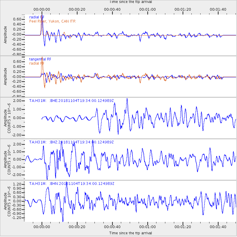
2018/11/04 (308) 19:26:03 GMT |
| Earthquake Depth: |
8.0 km |
| Earthquake Magnitude: |
5.9 Mww |
| Earthquake Catalog/Contributor: |
NEIC PDE/us |
|
| Network: |
TA USArray Transportable Network (new EarthScope stations) |
| Station: |
H31M Peel River, Yukon, CAN |
| Lat/Lon: |
65.81 N/134.34 W |
| Elevation: |
642 m |
|
| Distance: |
46.5 deg |
| Az: |
34.013 deg |
| Baz: |
284.021 deg |
| Ray Param: |
0.07059317 |
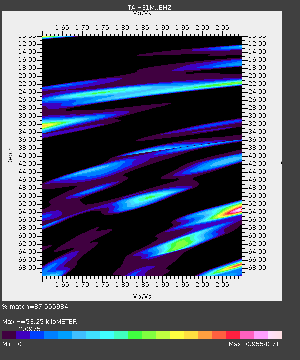
| Estimated Moho Depth: |
53.25 km |
| Estimated Crust Vp/Vs: |
2.10 |
| Assumed Crust Vp: |
6.419 km/s |
| Estimated Crust Vs: |
3.06 km/s |
| Estimated Crust Poisson's Ratio: |
0.35 |
|
| Radial Match: |
87.555984 % |
| Radial Bump: |
400 |
| Transverse Match: |
59.437183 % |
| Transverse Bump: |
400 |
| SOD ConfigId: |
13570011 |
| Insert Time: |
2019-05-01 18:12:15.088 +0000 |
| GWidth: |
2.5 |
| Max Bumps: |
400 |
| Tol: |
0.001 |
|
Signal To Noise
| Channel | StoN | STA | LTA |
| TA:H31M: :BHZ:20181104T19:34:00.124989Z | 4.1948023 | 1.151704E-6 | 2.7455502E-7 |
| TA:H31M: :BHN:20181104T19:34:00.124989Z | 1.8039644 | 6.1348123E-7 | 3.400739E-7 |
| TA:H31M: :BHE:20181104T19:34:00.124989Z | 4.5432367 | 8.52556E-7 | 1.8765387E-7 |
| Arrivals |
| Ps | 9.6 SECOND |
| PpPs | 24 SECOND |
| PsPs/PpSs | 34 SECOND |


