You are here: Home > Network List > TA - USArray Transportable Network (new EarthScope stations) Stations List
> Station M20K Styx River, AK, USA > Earthquake Result Viewer
M20K Styx River, AK, USA - Earthquake Result Viewer
| Earthquake location: |
Hokkaido, Japan Region |
| Earthquake latitude/longitude: |
44.6/145.6 |
| Earthquake time(UTC): |
2018/11/04 (308) 19:26:03 GMT |
| Earthquake Depth: |
8.0 km |
| Earthquake Magnitude: |
5.9 Mww |
| Earthquake Catalog/Contributor: |
NEIC PDE/us |
|
| Network: |
TA USArray Transportable Network (new EarthScope stations) |
| Station: |
M20K Styx River, AK, USA |
| Lat/Lon: |
61.88 N/153.13 W |
| Elevation: |
1107 m |
|
| Distance: |
38.9 deg |
| Az: |
41.457 deg |
| Baz: |
272.626 deg |
| Ray Param: |
0.07531958 |
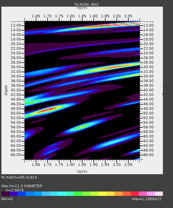
| Estimated Moho Depth: |
11.0 km |
| Estimated Crust Vp/Vs: |
2.09 |
| Assumed Crust Vp: |
6.566 km/s |
| Estimated Crust Vs: |
3.145 km/s |
| Estimated Crust Poisson's Ratio: |
0.35 |
|
| Radial Match: |
85.41615 % |
| Radial Bump: |
400 |
| Transverse Match: |
80.910126 % |
| Transverse Bump: |
400 |
| SOD ConfigId: |
13570011 |
| Insert Time: |
2019-05-01 18:12:49.574 +0000 |
| GWidth: |
2.5 |
| Max Bumps: |
400 |
| Tol: |
0.001 |
|

Signal To Noise
| Channel | StoN | STA | LTA |
| TA:M20K: :BHZ:20181104T19:32:57.950001Z | 6.4397144 | 1.4415641E-6 | 2.2385528E-7 |
| TA:M20K: :BHN:20181104T19:32:57.950001Z | 0.9355897 | 2.1491836E-7 | 2.2971433E-7 |
| TA:M20K: :BHE:20181104T19:32:57.950001Z | 6.5084057 | 1.0839595E-6 | 1.6654764E-7 |
| Arrivals |
| Ps | 1.9 SECOND |
| PpPs | 4.9 SECOND |
| PsPs/PpSs | 6.8 SECOND |


