You are here: Home > Network List > TA - USArray Transportable Network (new EarthScope stations) Stations List
> Station N15K Kwethluk River, AK, USA > Earthquake Result Viewer
N15K Kwethluk River, AK, USA - Earthquake Result Viewer
| Earthquake location: |
Hokkaido, Japan Region |
| Earthquake latitude/longitude: |
44.6/145.6 |
| Earthquake time(UTC): |
2018/11/04 (308) 19:26:03 GMT |
| Earthquake Depth: |
8.0 km |
| Earthquake Magnitude: |
5.9 Mww |
| Earthquake Catalog/Contributor: |
NEIC PDE/us |
|
| Network: |
TA USArray Transportable Network (new EarthScope stations) |
| Station: |
N15K Kwethluk River, AK, USA |
| Lat/Lon: |
60.17 N/160.09 W |
| Elevation: |
449 m |
|
| Distance: |
35.5 deg |
| Az: |
44.371 deg |
| Baz: |
268.866 deg |
| Ray Param: |
0.077194825 |
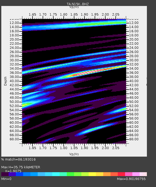
| Estimated Moho Depth: |
35.75 km |
| Estimated Crust Vp/Vs: |
1.91 |
| Assumed Crust Vp: |
6.182 km/s |
| Estimated Crust Vs: |
3.241 km/s |
| Estimated Crust Poisson's Ratio: |
0.31 |
|
| Radial Match: |
86.193016 % |
| Radial Bump: |
400 |
| Transverse Match: |
61.44645 % |
| Transverse Bump: |
400 |
| SOD ConfigId: |
13570011 |
| Insert Time: |
2019-05-01 18:13:01.870 +0000 |
| GWidth: |
2.5 |
| Max Bumps: |
400 |
| Tol: |
0.001 |
|

Signal To Noise
| Channel | StoN | STA | LTA |
| TA:N15K: :BHZ:20181104T19:32:29.400013Z | 3.5275388 | 1.3809351E-6 | 3.9147272E-7 |
| TA:N15K: :BHN:20181104T19:32:29.400013Z | 1.3630972 | 4.522418E-7 | 3.3177517E-7 |
| TA:N15K: :BHE:20181104T19:32:29.400013Z | 2.1973991 | 7.4951043E-7 | 3.410898E-7 |
| Arrivals |
| Ps | 5.6 SECOND |
| PpPs | 16 SECOND |
| PsPs/PpSs | 21 SECOND |


