You are here: Home > Network List > TA - USArray Transportable Network (new EarthScope stations) Stations List
> Station O14K Tigyukauivet Mountain, AK, USA > Earthquake Result Viewer
O14K Tigyukauivet Mountain, AK, USA - Earthquake Result Viewer
| Earthquake location: |
Hokkaido, Japan Region |
| Earthquake latitude/longitude: |
44.6/145.6 |
| Earthquake time(UTC): |
2018/11/04 (308) 19:26:03 GMT |
| Earthquake Depth: |
8.0 km |
| Earthquake Magnitude: |
5.9 Mww |
| Earthquake Catalog/Contributor: |
NEIC PDE/us |
|
| Network: |
TA USArray Transportable Network (new EarthScope stations) |
| Station: |
O14K Tigyukauivet Mountain, AK, USA |
| Lat/Lon: |
59.25 N/161.26 W |
| Elevation: |
129 m |
|
| Distance: |
34.9 deg |
| Az: |
45.946 deg |
| Baz: |
269.143 deg |
| Ray Param: |
0.07751242 |
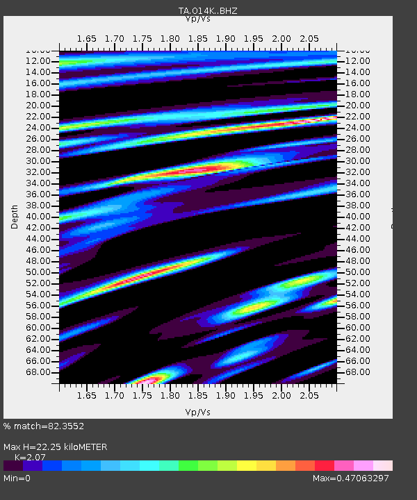
| Estimated Moho Depth: |
22.25 km |
| Estimated Crust Vp/Vs: |
2.07 |
| Assumed Crust Vp: |
6.24 km/s |
| Estimated Crust Vs: |
3.014 km/s |
| Estimated Crust Poisson's Ratio: |
0.35 |
|
| Radial Match: |
82.3552 % |
| Radial Bump: |
400 |
| Transverse Match: |
54.305515 % |
| Transverse Bump: |
400 |
| SOD ConfigId: |
13570011 |
| Insert Time: |
2019-05-01 18:13:09.704 +0000 |
| GWidth: |
2.5 |
| Max Bumps: |
400 |
| Tol: |
0.001 |
|

Signal To Noise
| Channel | StoN | STA | LTA |
| TA:O14K: :BHZ:20181104T19:32:24.150013Z | 4.334317 | 1.6020768E-6 | 3.6962612E-7 |
| TA:O14K: :BHN:20181104T19:32:24.150013Z | 1.4136666 | 3.2588503E-7 | 2.3052466E-7 |
| TA:O14K: :BHE:20181104T19:32:24.150013Z | 3.7483623 | 1.2192205E-6 | 3.2526754E-7 |
| Arrivals |
| Ps | 4.1 SECOND |
| PpPs | 10 SECOND |
| PsPs/PpSs | 14 SECOND |


