You are here: Home > Network List > TA - USArray Transportable Network (new EarthScope stations) Stations List
> Station O15K Ungalikthiuk River, AK, USA > Earthquake Result Viewer
O15K Ungalikthiuk River, AK, USA - Earthquake Result Viewer
| Earthquake location: |
Hokkaido, Japan Region |
| Earthquake latitude/longitude: |
44.6/145.6 |
| Earthquake time(UTC): |
2018/11/04 (308) 19:26:03 GMT |
| Earthquake Depth: |
8.0 km |
| Earthquake Magnitude: |
5.9 Mww |
| Earthquake Catalog/Contributor: |
NEIC PDE/us |
|
| Network: |
TA USArray Transportable Network (new EarthScope stations) |
| Station: |
O15K Ungalikthiuk River, AK, USA |
| Lat/Lon: |
59.18 N/159.82 W |
| Elevation: |
306 m |
|
| Distance: |
35.6 deg |
| Az: |
46.083 deg |
| Baz: |
270.489 deg |
| Ray Param: |
0.07712461 |
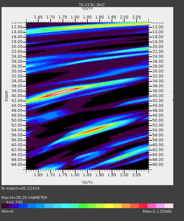
| Estimated Moho Depth: |
38.25 km |
| Estimated Crust Vp/Vs: |
1.75 |
| Assumed Crust Vp: |
6.24 km/s |
| Estimated Crust Vs: |
3.576 km/s |
| Estimated Crust Poisson's Ratio: |
0.26 |
|
| Radial Match: |
80.02424 % |
| Radial Bump: |
338 |
| Transverse Match: |
67.969185 % |
| Transverse Bump: |
400 |
| SOD ConfigId: |
13570011 |
| Insert Time: |
2019-05-01 18:13:10.687 +0000 |
| GWidth: |
2.5 |
| Max Bumps: |
400 |
| Tol: |
0.001 |
|

Signal To Noise
| Channel | StoN | STA | LTA |
| TA:O15K: :BHZ:20181104T19:32:30.525013Z | 7.404348 | 1.5923987E-6 | 2.1506266E-7 |
| TA:O15K: :BHN:20181104T19:32:30.525013Z | 1.0097163 | 1.934105E-7 | 1.9154935E-7 |
| TA:O15K: :BHE:20181104T19:32:30.525013Z | 3.3391862 | 1.0535715E-6 | 3.1551747E-7 |
| Arrivals |
| Ps | 4.9 SECOND |
| PpPs | 16 SECOND |
| PsPs/PpSs | 21 SECOND |


