You are here: Home > Network List > TA - USArray Transportable Network (new EarthScope stations) Stations List
> Station E20A Meyer Farm, Musselshell, MT, USA > Earthquake Result Viewer
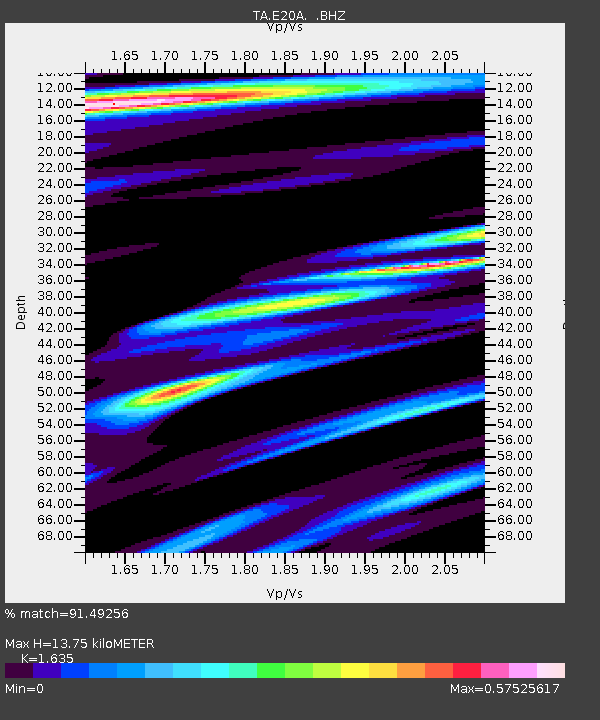
E20A Meyer Farm, Musselshell, MT, USA - Earthquake Result Viewer
| Earthquake location: |
Near S. Coast Of Honshu, Japan |
| Earthquake latitude/longitude: |
33.2/137.9 |
| Earthquake time(UTC): |
2009/08/09 (221) 10:55:55 GMT |
| Earthquake Depth: |
297 km |
| Earthquake Magnitude: |
6.5 MB, 7.1 MW, 7.1 MW |
| Earthquake Catalog/Contributor: |
WHDF/NEIC |
|
| Network: |
TA USArray Transportable Network (new EarthScope stations) |
| Station: |
E20A Meyer Farm, Musselshell, MT, USA |
| Lat/Lon: |
46.50 N/108.13 W |
| Elevation: |
954 m |
|
| Distance: |
80.9 deg |
| Az: |
39.753 deg |
| Baz: |
309.058 deg |
| Ray Param: |
0.04719955 |
| Estimated Moho Depth: |
13.75 km |
| Estimated Crust Vp/Vs: |
1.63 |
| Assumed Crust Vp: |
6.518 km/s |
| Estimated Crust Vs: |
3.987 km/s |
| Estimated Crust Poisson's Ratio: |
0.20 |
|
| Radial Match: |
91.49256 % |
| Radial Bump: |
400 |
| Transverse Match: |
81.04089 % |
| Transverse Bump: |
400 |
| SOD ConfigId: |
2622 |
| Insert Time: |
2010-03-06 17:37:25.810 +0000 |
| GWidth: |
2.5 |
| Max Bumps: |
400 |
| Tol: |
0.001 |
|

Signal To Noise
| Channel | StoN | STA | LTA |
| TA:E20A: :BHZ:20090809T11:07:05.675002Z | 111.85854 | 1.0003749E-5 | 8.9432135E-8 |
| TA:E20A: :BHN:20090809T11:07:05.675002Z | 23.717497 | 1.8573807E-6 | 7.8312674E-8 |
| TA:E20A: :BHE:20090809T11:07:05.675002Z | 23.933102 | 2.6205216E-6 | 1.0949361E-7 |
| Arrivals |
| Ps | 1.4 SECOND |
| PpPs | 5.4 SECOND |
| PsPs/PpSs | 6.8 SECOND |


