You are here: Home > Network List > IW - Intermountain West Stations List
> Station MOOW Moose Ponds, Wyoming, USA > Earthquake Result Viewer
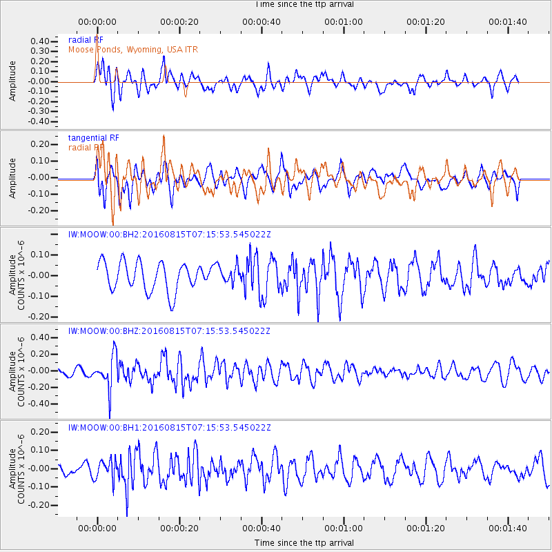
MOOW Moose Ponds, Wyoming, USA - Earthquake Result Viewer
*The percent match for this event was below the threshold and hence no stack was calculated.
| Earthquake location: |
Near East Coast Of Honshu, Japan |
| Earthquake latitude/longitude: |
37.4/141.7 |
| Earthquake time(UTC): |
2016/08/15 (228) 07:04:40 GMT |
| Earthquake Depth: |
28 km |
| Earthquake Magnitude: |
5.6 MB |
| Earthquake Catalog/Contributor: |
NEIC PDE/NEIC COMCAT |
|
| Network: |
IW Intermountain West |
| Station: |
MOOW Moose Ponds, Wyoming, USA |
| Lat/Lon: |
43.75 N/110.74 W |
| Elevation: |
2128 m |
|
| Distance: |
75.9 deg |
| Az: |
45.442 deg |
| Baz: |
308.483 deg |
| Ray Param: |
$rayparam |
*The percent match for this event was below the threshold and hence was not used in the summary stack. |
|
| Radial Match: |
58.460693 % |
| Radial Bump: |
400 |
| Transverse Match: |
56.295486 % |
| Transverse Bump: |
400 |
| SOD ConfigId: |
1634031 |
| Insert Time: |
2016-08-29 07:07:37.776 +0000 |
| GWidth: |
2.5 |
| Max Bumps: |
400 |
| Tol: |
0.001 |
|
Signal To Noise
| Channel | StoN | STA | LTA |
| IW:MOOW:00:BHZ:20160815T07:15:53.545022Z | 4.8345423 | 2.0208451E-7 | 4.1800135E-8 |
| IW:MOOW:00:BH1:20160815T07:15:53.545022Z | 1.3667156 | 5.2764623E-8 | 3.8606878E-8 |
| IW:MOOW:00:BH2:20160815T07:15:53.545022Z | 0.6120447 | 4.2858716E-8 | 7.002547E-8 |
| Arrivals |
| Ps | |
| PpPs | |
| PsPs/PpSs | |


