You are here: Home > Network List > 5H - Central Virginia and South Carolina seismic monitoring experiment Stations List
> Station PWTN Powhatan W.M.A., VA > Earthquake Result Viewer
PWTN Powhatan W.M.A., VA - Earthquake Result Viewer
| Earthquake location: |
Jan Mayen Island Region |
| Earthquake latitude/longitude: |
71.6/-11.2 |
| Earthquake time(UTC): |
2018/11/09 (313) 01:49:40 GMT |
| Earthquake Depth: |
10 km |
| Earthquake Magnitude: |
6.8 Mww |
| Earthquake Catalog/Contributor: |
NEIC PDE/us |
|
| Network: |
5H Central Virginia and South Carolina seismic monitoring experiment |
| Station: |
PWTN Powhatan W.M.A., VA |
| Lat/Lon: |
37.53 N/77.99 W |
| Elevation: |
99 m |
|
| Distance: |
47.6 deg |
| Az: |
261.801 deg |
| Baz: |
23.26 deg |
| Ray Param: |
0.06991241 |
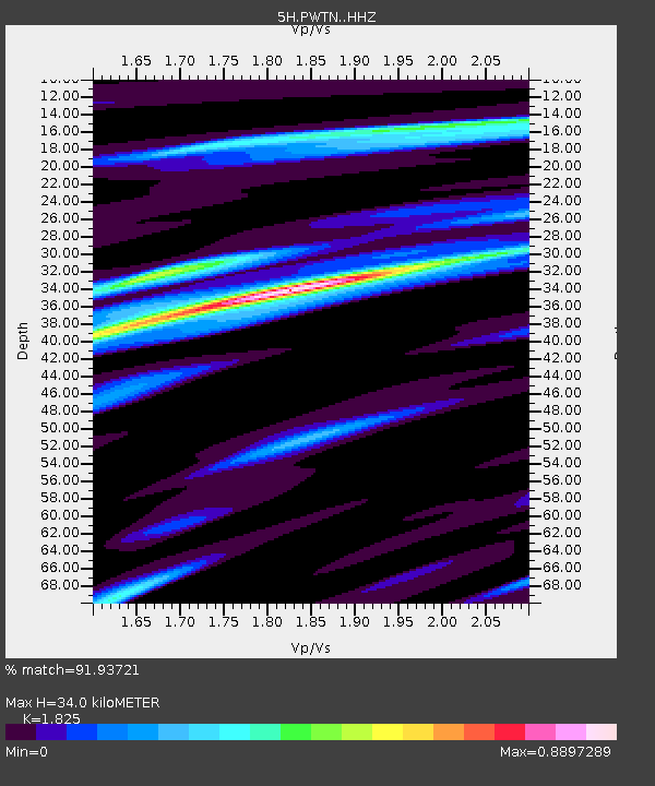
| Estimated Moho Depth: |
34.0 km |
| Estimated Crust Vp/Vs: |
1.83 |
| Assumed Crust Vp: |
6.565 km/s |
| Estimated Crust Vs: |
3.597 km/s |
| Estimated Crust Poisson's Ratio: |
0.29 |
|
| Radial Match: |
91.93721 % |
| Radial Bump: |
289 |
| Transverse Match: |
76.105545 % |
| Transverse Bump: |
400 |
| SOD ConfigId: |
13570011 |
| Insert Time: |
2019-05-01 18:26:40.415 +0000 |
| GWidth: |
2.5 |
| Max Bumps: |
400 |
| Tol: |
0.001 |
|

Signal To Noise
| Channel | StoN | STA | LTA |
| 5H:PWTN: :HHZ:20181109T01:57:44.664996Z | 1.4263421 | 4.2549132E-7 | 2.9830943E-7 |
| 5H:PWTN: :HHN:20181109T01:57:44.664996Z | 1.7347018 | 2.5411072E-7 | 1.464867E-7 |
| 5H:PWTN: :HHE:20181109T01:57:44.664996Z | 1.0325114 | 2.1853062E-7 | 2.116496E-7 |
| Arrivals |
| Ps | 4.5 SECOND |
| PpPs | 14 SECOND |
| PsPs/PpSs | 18 SECOND |


