You are here: Home > Network List > AK - Alaska Regional Network Stations List
> Station DOT Dot Lake > Earthquake Result Viewer
DOT Dot Lake - Earthquake Result Viewer
| Earthquake location: |
Jan Mayen Island Region |
| Earthquake latitude/longitude: |
71.6/-11.2 |
| Earthquake time(UTC): |
2018/11/09 (313) 01:49:40 GMT |
| Earthquake Depth: |
10 km |
| Earthquake Magnitude: |
6.8 Mww |
| Earthquake Catalog/Contributor: |
NEIC PDE/us |
|
| Network: |
AK Alaska Regional Network |
| Station: |
DOT Dot Lake |
| Lat/Lon: |
63.65 N/144.06 W |
| Elevation: |
671 m |
|
| Distance: |
41.2 deg |
| Az: |
330.2 deg |
| Baz: |
20.685 deg |
| Ray Param: |
0.073944874 |
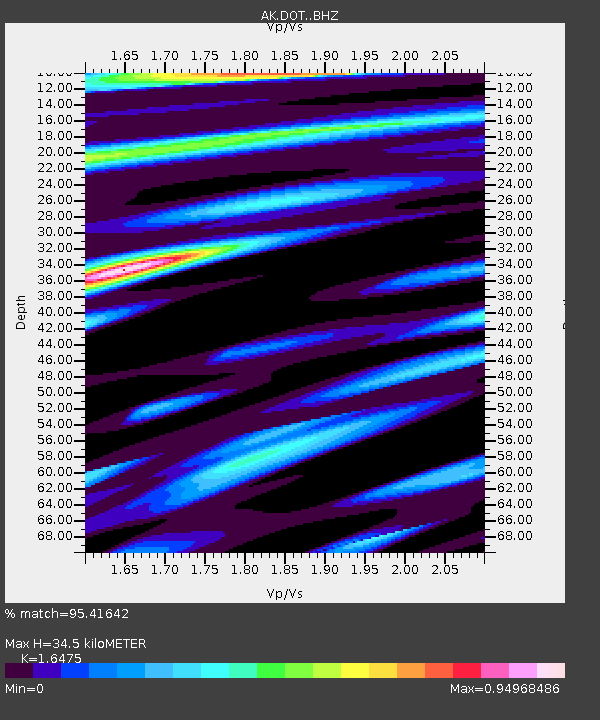
| Estimated Moho Depth: |
34.5 km |
| Estimated Crust Vp/Vs: |
1.65 |
| Assumed Crust Vp: |
6.566 km/s |
| Estimated Crust Vs: |
3.986 km/s |
| Estimated Crust Poisson's Ratio: |
0.21 |
|
| Radial Match: |
95.41642 % |
| Radial Bump: |
353 |
| Transverse Match: |
60.893776 % |
| Transverse Bump: |
400 |
| SOD ConfigId: |
13570011 |
| Insert Time: |
2019-05-01 18:27:23.530 +0000 |
| GWidth: |
2.5 |
| Max Bumps: |
400 |
| Tol: |
0.001 |
|

Signal To Noise
| Channel | StoN | STA | LTA |
| AK:DOT: :BHZ:20181109T01:56:53.84801Z | 6.1748066 | 2.2342483E-6 | 3.6183292E-7 |
| AK:DOT: :BHN:20181109T01:56:53.84801Z | 4.631816 | 1.2281001E-6 | 2.6514442E-7 |
| AK:DOT: :BHE:20181109T01:56:53.84801Z | 2.6462948 | 6.026495E-7 | 2.277333E-7 |
| Arrivals |
| Ps | 3.7 SECOND |
| PpPs | 13 SECOND |
| PsPs/PpSs | 17 SECOND |


