You are here: Home > Network List > AK - Alaska Regional Network Stations List
> Station GLB Gilahina Butte, AK, USA > Earthquake Result Viewer
GLB Gilahina Butte, AK, USA - Earthquake Result Viewer
| Earthquake location: |
Jan Mayen Island Region |
| Earthquake latitude/longitude: |
71.6/-11.2 |
| Earthquake time(UTC): |
2018/11/09 (313) 01:49:40 GMT |
| Earthquake Depth: |
10 km |
| Earthquake Magnitude: |
6.8 Mww |
| Earthquake Catalog/Contributor: |
NEIC PDE/us |
|
| Network: |
AK Alaska Regional Network |
| Station: |
GLB Gilahina Butte, AK, USA |
| Lat/Lon: |
61.44 N/143.81 W |
| Elevation: |
855 m |
|
| Distance: |
43.2 deg |
| Az: |
328.893 deg |
| Baz: |
19.939 deg |
| Ray Param: |
0.072684474 |
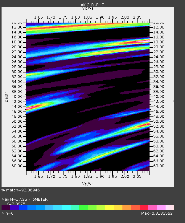
| Estimated Moho Depth: |
17.25 km |
| Estimated Crust Vp/Vs: |
2.10 |
| Assumed Crust Vp: |
6.566 km/s |
| Estimated Crust Vs: |
3.13 km/s |
| Estimated Crust Poisson's Ratio: |
0.35 |
|
| Radial Match: |
92.36946 % |
| Radial Bump: |
333 |
| Transverse Match: |
68.44386 % |
| Transverse Bump: |
400 |
| SOD ConfigId: |
13570011 |
| Insert Time: |
2019-05-01 18:27:28.289 +0000 |
| GWidth: |
2.5 |
| Max Bumps: |
400 |
| Tol: |
0.001 |
|

Signal To Noise
| Channel | StoN | STA | LTA |
| AK:GLB: :BHZ:20181109T01:57:10.427997Z | 5.2563086 | 1.9424544E-6 | 3.6954725E-7 |
| AK:GLB: :BHN:20181109T01:57:10.427997Z | 2.9876544 | 1.1786727E-6 | 3.9451442E-7 |
| AK:GLB: :BHE:20181109T01:57:10.427997Z | 1.3168529 | 5.208324E-7 | 3.9551293E-7 |
| Arrivals |
| Ps | 3.1 SECOND |
| PpPs | 7.7 SECOND |
| PsPs/PpSs | 11 SECOND |


