You are here: Home > Network List > C0 - Colorado Geological Survey Seismic Network Stations List
> Station HAYD Hayden Colorado > Earthquake Result Viewer
HAYD Hayden Colorado - Earthquake Result Viewer
| Earthquake location: |
Jan Mayen Island Region |
| Earthquake latitude/longitude: |
71.6/-11.2 |
| Earthquake time(UTC): |
2018/11/09 (313) 01:49:40 GMT |
| Earthquake Depth: |
10 km |
| Earthquake Magnitude: |
6.8 Mww |
| Earthquake Catalog/Contributor: |
NEIC PDE/us |
|
| Network: |
C0 Colorado Geological Survey Seismic Network |
| Station: |
HAYD Hayden Colorado |
| Lat/Lon: |
40.53 N/107.27 W |
| Elevation: |
2202 m |
|
| Distance: |
53.9 deg |
| Az: |
290.353 deg |
| Baz: |
22.964 deg |
| Ray Param: |
0.06575677 |
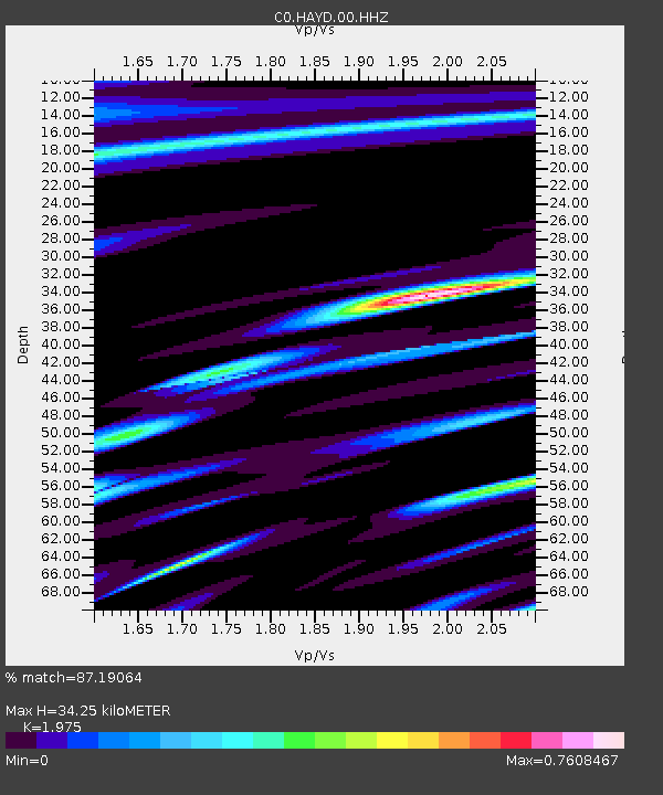
| Estimated Moho Depth: |
34.25 km |
| Estimated Crust Vp/Vs: |
1.98 |
| Assumed Crust Vp: |
6.159 km/s |
| Estimated Crust Vs: |
3.118 km/s |
| Estimated Crust Poisson's Ratio: |
0.33 |
|
| Radial Match: |
87.19064 % |
| Radial Bump: |
400 |
| Transverse Match: |
82.96587 % |
| Transverse Bump: |
400 |
| SOD ConfigId: |
13570011 |
| Insert Time: |
2019-05-01 18:29:08.618 +0000 |
| GWidth: |
2.5 |
| Max Bumps: |
400 |
| Tol: |
0.001 |
|

Signal To Noise
| Channel | StoN | STA | LTA |
| C0:HAYD:00:HHZ:20181109T01:58:32.788989Z | 6.3027306 | 5.0099754E-7 | 7.948896E-8 |
| C0:HAYD:00:HHN:20181109T01:58:32.788989Z | 1.9156581 | 2.3167101E-7 | 1.2093547E-7 |
| C0:HAYD:00:HHE:20181109T01:58:32.788989Z | 0.6702682 | 8.5156564E-8 | 1.270485E-7 |
| Arrivals |
| Ps | 5.7 SECOND |
| PpPs | 16 SECOND |
| PsPs/PpSs | 22 SECOND |


