You are here: Home > Network List > CC - Cascade Chain Volcano Monitoring Stations List
> Station HUSB The Husband > Earthquake Result Viewer
HUSB The Husband - Earthquake Result Viewer
| Earthquake location: |
Jan Mayen Island Region |
| Earthquake latitude/longitude: |
71.6/-11.2 |
| Earthquake time(UTC): |
2018/11/09 (313) 01:49:40 GMT |
| Earthquake Depth: |
10 km |
| Earthquake Magnitude: |
6.8 Mww |
| Earthquake Catalog/Contributor: |
NEIC PDE/us |
|
| Network: |
CC Cascade Chain Volcano Monitoring |
| Station: |
HUSB The Husband |
| Lat/Lon: |
44.12 N/121.85 W |
| Elevation: |
2038 m |
|
| Distance: |
54.7 deg |
| Az: |
304.335 deg |
| Baz: |
21.325 deg |
| Ray Param: |
0.06526821 |
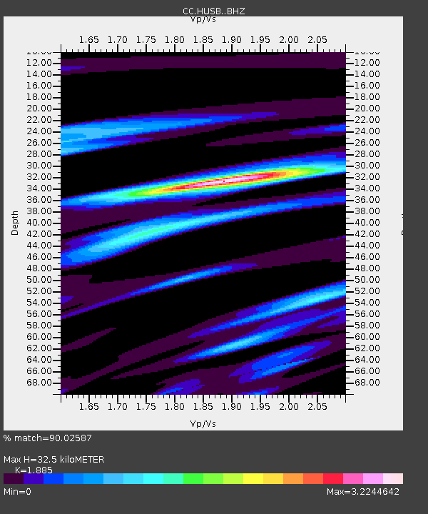
| Estimated Moho Depth: |
32.5 km |
| Estimated Crust Vp/Vs: |
1.88 |
| Assumed Crust Vp: |
6.597 km/s |
| Estimated Crust Vs: |
3.5 km/s |
| Estimated Crust Poisson's Ratio: |
0.30 |
|
| Radial Match: |
90.02587 % |
| Radial Bump: |
400 |
| Transverse Match: |
84.25758 % |
| Transverse Bump: |
400 |
| SOD ConfigId: |
13570011 |
| Insert Time: |
2019-05-01 18:29:31.222 +0000 |
| GWidth: |
2.5 |
| Max Bumps: |
400 |
| Tol: |
0.001 |
|

Signal To Noise
| Channel | StoN | STA | LTA |
| CC:HUSB: :BHZ:20181109T01:58:38.419971Z | 16.37856 | 2.4534345E-6 | 1.497955E-7 |
| CC:HUSB: :BHN:20181109T01:58:38.419971Z | 7.051783 | 1.9289976E-6 | 2.7354747E-7 |
| CC:HUSB: :BHE:20181109T01:58:38.419971Z | 2.4313507 | 4.3192014E-7 | 1.7764616E-7 |
| Arrivals |
| Ps | 4.6 SECOND |
| PpPs | 13 SECOND |
| PsPs/PpSs | 18 SECOND |


