You are here: Home > Network List > CI - Caltech Regional Seismic Network Stations List
> Station VES Vestal, Richgrove, CA, USA > Earthquake Result Viewer
VES Vestal, Richgrove, CA, USA - Earthquake Result Viewer
| Earthquake location: |
Jan Mayen Island Region |
| Earthquake latitude/longitude: |
71.6/-11.2 |
| Earthquake time(UTC): |
2018/11/09 (313) 01:49:40 GMT |
| Earthquake Depth: |
10 km |
| Earthquake Magnitude: |
6.8 Mww |
| Earthquake Catalog/Contributor: |
NEIC PDE/us |
|
| Network: |
CI Caltech Regional Seismic Network |
| Station: |
VES Vestal, Richgrove, CA, USA |
| Lat/Lon: |
35.84 N/119.08 W |
| Elevation: |
154 m |
|
| Distance: |
61.7 deg |
| Az: |
298.563 deg |
| Baz: |
20.052 deg |
| Ray Param: |
0.060698334 |
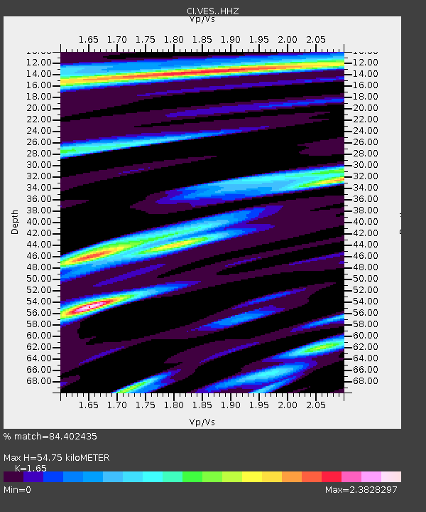
| Estimated Moho Depth: |
54.75 km |
| Estimated Crust Vp/Vs: |
1.65 |
| Assumed Crust Vp: |
6.1 km/s |
| Estimated Crust Vs: |
3.697 km/s |
| Estimated Crust Poisson's Ratio: |
0.21 |
|
| Radial Match: |
84.402435 % |
| Radial Bump: |
400 |
| Transverse Match: |
56.39341 % |
| Transverse Bump: |
400 |
| SOD ConfigId: |
13570011 |
| Insert Time: |
2019-05-01 18:30:35.222 +0000 |
| GWidth: |
2.5 |
| Max Bumps: |
400 |
| Tol: |
0.001 |
|

Signal To Noise
| Channel | StoN | STA | LTA |
| CI:VES: :HHZ:20181109T01:59:27.207996Z | 4.338228 | 9.1558894E-7 | 2.1105136E-7 |
| CI:VES: :HHN:20181109T01:59:27.207996Z | 1.5953734 | 7.7010014E-7 | 4.827084E-7 |
| CI:VES: :HHE:20181109T01:59:27.207996Z | 1.4977674 | 7.570981E-7 | 5.054844E-7 |
| Arrivals |
| Ps | 6.1 SECOND |
| PpPs | 23 SECOND |
| PsPs/PpSs | 29 SECOND |


