You are here: Home > Network List > CN - Canadian National Seismograph Network Stations List
> Station ATKO Atikokan Iron Mine, ON, CA > Earthquake Result Viewer
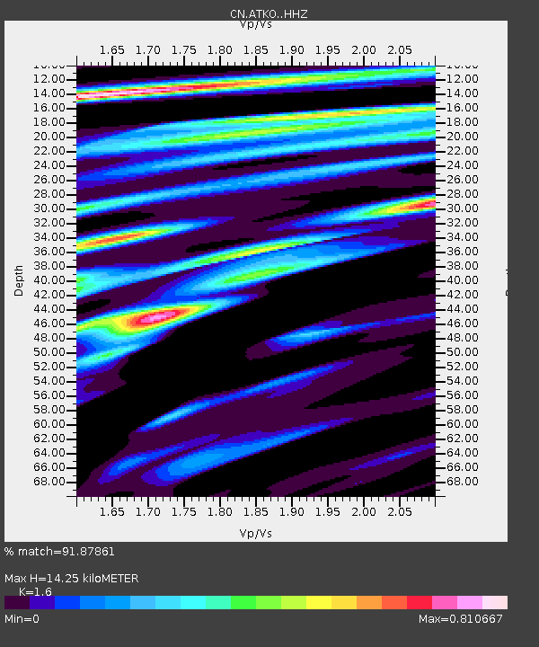
ATKO Atikokan Iron Mine, ON, CA - Earthquake Result Viewer
| Earthquake location: |
Jan Mayen Island Region |
| Earthquake latitude/longitude: |
71.6/-11.2 |
| Earthquake time(UTC): |
2018/11/09 (313) 01:49:40 GMT |
| Earthquake Depth: |
10 km |
| Earthquake Magnitude: |
6.8 Mww |
| Earthquake Catalog/Contributor: |
NEIC PDE/us |
|
| Network: |
CN Canadian National Seismograph Network |
| Station: |
ATKO Atikokan Iron Mine, ON, CA |
| Lat/Lon: |
48.82 N/91.60 W |
| Elevation: |
383 m |
|
| Distance: |
41.7 deg |
| Az: |
281.545 deg |
| Baz: |
28.049 deg |
| Ray Param: |
0.07363738 |
| Estimated Moho Depth: |
14.25 km |
| Estimated Crust Vp/Vs: |
1.60 |
| Assumed Crust Vp: |
6.467 km/s |
| Estimated Crust Vs: |
4.042 km/s |
| Estimated Crust Poisson's Ratio: |
0.18 |
|
| Radial Match: |
91.87861 % |
| Radial Bump: |
327 |
| Transverse Match: |
68.99689 % |
| Transverse Bump: |
400 |
| SOD ConfigId: |
13570011 |
| Insert Time: |
2019-05-01 18:30:48.919 +0000 |
| GWidth: |
2.5 |
| Max Bumps: |
400 |
| Tol: |
0.001 |
|

Signal To Noise
| Channel | StoN | STA | LTA |
| CN:ATKO: :HHZ:20181109T01:56:57.849994Z | 2.0615005 | 6.9296146E-7 | 3.3614418E-7 |
| CN:ATKO: :HHN:20181109T01:56:57.849994Z | 1.8700391 | 4.8331424E-7 | 2.584514E-7 |
| CN:ATKO: :HHE:20181109T01:56:57.849994Z | 1.0896622 | 2.0868086E-7 | 1.9150967E-7 |
| Arrivals |
| Ps | 1.4 SECOND |
| PpPs | 5.3 SECOND |
| PsPs/PpSs | 6.7 SECOND |


