You are here: Home > Network List > CN - Canadian National Seismograph Network Stations List
> Station LLLB Lillooet, BC, CA > Earthquake Result Viewer
LLLB Lillooet, BC, CA - Earthquake Result Viewer
| Earthquake location: |
Jan Mayen Island Region |
| Earthquake latitude/longitude: |
71.6/-11.2 |
| Earthquake time(UTC): |
2018/11/09 (313) 01:49:40 GMT |
| Earthquake Depth: |
10 km |
| Earthquake Magnitude: |
6.8 Mww |
| Earthquake Catalog/Contributor: |
NEIC PDE/us |
|
| Network: |
CN Canadian National Seismograph Network |
| Station: |
LLLB Lillooet, BC, CA |
| Lat/Lon: |
50.61 N/121.88 W |
| Elevation: |
700 m |
|
| Distance: |
48.7 deg |
| Az: |
307.498 deg |
| Baz: |
23.263 deg |
| Ray Param: |
0.06917143 |
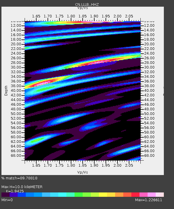
| Estimated Moho Depth: |
10.0 km |
| Estimated Crust Vp/Vs: |
1.94 |
| Assumed Crust Vp: |
6.597 km/s |
| Estimated Crust Vs: |
3.396 km/s |
| Estimated Crust Poisson's Ratio: |
0.32 |
|
| Radial Match: |
89.78818 % |
| Radial Bump: |
400 |
| Transverse Match: |
85.21489 % |
| Transverse Bump: |
400 |
| SOD ConfigId: |
13570011 |
| Insert Time: |
2019-05-01 18:31:06.075 +0000 |
| GWidth: |
2.5 |
| Max Bumps: |
400 |
| Tol: |
0.001 |
|
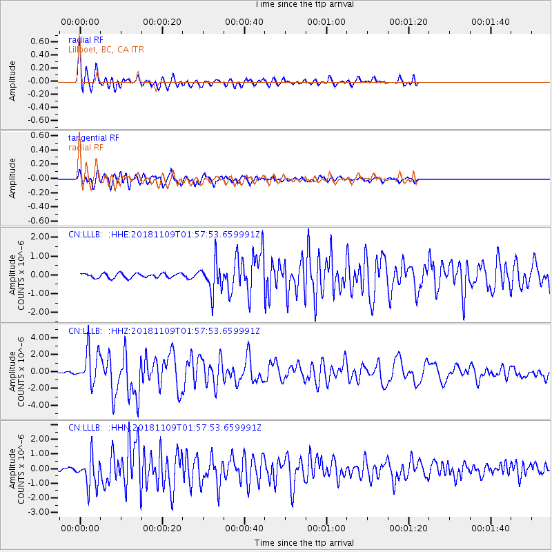
Signal To Noise
| Channel | StoN | STA | LTA |
| CN:LLLB: :HHZ:20181109T01:57:53.659991Z | 21.29885 | 2.0987734E-6 | 9.853928E-8 |
| CN:LLLB: :HHN:20181109T01:57:53.659991Z | 8.220964 | 1.0366873E-6 | 1.2610289E-7 |
| CN:LLLB: :HHE:20181109T01:57:53.659991Z | 6.872646 | 8.1976793E-7 | 1.1927982E-7 |
| Arrivals |
| Ps | 1.5 SECOND |
| PpPs | 4.2 SECOND |
| PsPs/PpSs | 5.7 SECOND |


