You are here: Home > Network List > IE - INL Seismic Monitoring Program Stations List
> Station BCYI Bear Canyon, Idaho, USA > Earthquake Result Viewer
BCYI Bear Canyon, Idaho, USA - Earthquake Result Viewer
| Earthquake location: |
Jan Mayen Island Region |
| Earthquake latitude/longitude: |
71.6/-11.2 |
| Earthquake time(UTC): |
2018/11/09 (313) 01:49:40 GMT |
| Earthquake Depth: |
10 km |
| Earthquake Magnitude: |
6.8 Mww |
| Earthquake Catalog/Contributor: |
NEIC PDE/us |
|
| Network: |
IE INL Seismic Monitoring Program |
| Station: |
BCYI Bear Canyon, Idaho, USA |
| Lat/Lon: |
44.31 N/113.41 W |
| Elevation: |
2194 m |
|
| Distance: |
52.3 deg |
| Az: |
297.433 deg |
| Baz: |
23.088 deg |
| Ray Param: |
0.066879466 |
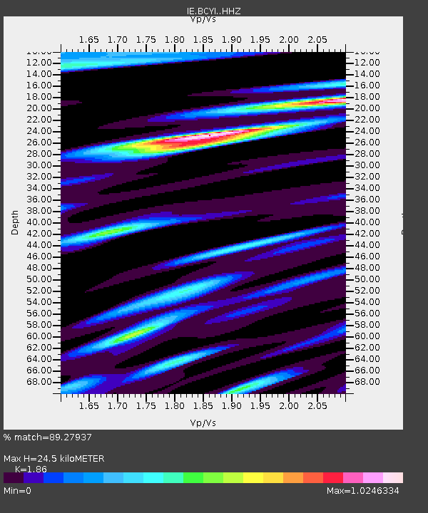
| Estimated Moho Depth: |
24.5 km |
| Estimated Crust Vp/Vs: |
1.86 |
| Assumed Crust Vp: |
6.577 km/s |
| Estimated Crust Vs: |
3.536 km/s |
| Estimated Crust Poisson's Ratio: |
0.30 |
|
| Radial Match: |
89.27937 % |
| Radial Bump: |
400 |
| Transverse Match: |
73.765274 % |
| Transverse Bump: |
400 |
| SOD ConfigId: |
13570011 |
| Insert Time: |
2019-05-01 18:32:13.637 +0000 |
| GWidth: |
2.5 |
| Max Bumps: |
400 |
| Tol: |
0.001 |
|

Signal To Noise
| Channel | StoN | STA | LTA |
| IE:BCYI: :HHZ:20181109T01:58:20.249988Z | 8.19156 | 1.1948277E-6 | 1.4586084E-7 |
| IE:BCYI: :HHN:20181109T01:58:20.249988Z | 5.4169464 | 7.086531E-7 | 1.308215E-7 |
| IE:BCYI: :HHE:20181109T01:58:20.249988Z | 1.9344001 | 3.3084808E-7 | 1.7103395E-7 |
| Arrivals |
| Ps | 3.4 SECOND |
| PpPs | 10 SECOND |
| PsPs/PpSs | 13 SECOND |


