You are here: Home > Network List > TA - USArray Transportable Network (new EarthScope stations) Stations List
> Station G04A Mulino, OR, USA > Earthquake Result Viewer
G04A Mulino, OR, USA - Earthquake Result Viewer
| Earthquake location: |
Near West Coast Of Colombia |
| Earthquake latitude/longitude: |
3.0/-78.0 |
| Earthquake time(UTC): |
2007/09/10 (253) 01:49:14 GMT |
| Earthquake Depth: |
31 km |
| Earthquake Magnitude: |
6.1 MB, 6.7 MS, 6.8 MW |
| Earthquake Catalog/Contributor: |
WHDF/NEIC |
|
| Network: |
TA USArray Transportable Network (new EarthScope stations) |
| Station: |
G04A Mulino, OR, USA |
| Lat/Lon: |
45.21 N/122.48 W |
| Elevation: |
273 m |
|
| Distance: |
57.3 deg |
| Az: |
323.926 deg |
| Baz: |
123.714 deg |
| Ray Param: |
0.06351664 |
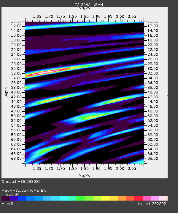
| Estimated Moho Depth: |
31.25 km |
| Estimated Crust Vp/Vs: |
1.69 |
| Assumed Crust Vp: |
6.566 km/s |
| Estimated Crust Vs: |
3.885 km/s |
| Estimated Crust Poisson's Ratio: |
0.23 |
|
| Radial Match: |
88.288635 % |
| Radial Bump: |
400 |
| Transverse Match: |
77.23469 % |
| Transverse Bump: |
400 |
| SOD ConfigId: |
2564 |
| Insert Time: |
2010-03-06 17:40:43.666 +0000 |
| GWidth: |
2.5 |
| Max Bumps: |
400 |
| Tol: |
0.001 |
|

Signal To Noise
| Channel | StoN | STA | LTA |
| TA:G04A: :BHN:20070910T01:58:28.375029Z | 2.5168242 | 7.6916587E-7 | 3.0560966E-7 |
| TA:G04A: :BHE:20070910T01:58:28.375029Z | 1.2529441 | 4.9329043E-7 | 3.9370508E-7 |
| TA:G04A: :BHZ:20070910T01:58:28.375029Z | 5.8309474 | 1.4522161E-6 | 2.490532E-7 |
| Arrivals |
| Ps | 3.5 SECOND |
| PpPs | 12 SECOND |
| PsPs/PpSs | 16 SECOND |


