You are here: Home > Network List > LD - Lamont-Doherty Cooperative Seismographic Network Stations List
> Station PANJ Princeton, NJ > Earthquake Result Viewer
PANJ Princeton, NJ - Earthquake Result Viewer

| Earthquake location: |
Jan Mayen Island Region |
| Earthquake latitude/longitude: |
71.6/-11.2 |
| Earthquake time(UTC): |
2018/11/09 (313) 01:49:40 GMT |
| Earthquake Depth: |
10 km |
| Earthquake Magnitude: |
6.8 Mww |
| Earthquake Catalog/Contributor: |
NEIC PDE/us |
|
| Network: |
LD Lamont-Doherty Cooperative Seismographic Network |
| Station: |
PANJ Princeton, NJ |
| Lat/Lon: |
40.38 N/74.70 W |
| Elevation: |
100 m |
|
| Distance: |
43.9 deg |
| Az: |
260.122 deg |
| Baz: |
24.145 deg |
| Ray Param: |
0.07223374 |
| Estimated Moho Depth: |
16.25 km |
| Estimated Crust Vp/Vs: |
2.08 |
| Assumed Crust Vp: |
6.283 km/s |
| Estimated Crust Vs: |
3.017 km/s |
| Estimated Crust Poisson's Ratio: |
0.35 |
|
| Radial Match: |
85.88432 % |
| Radial Bump: |
333 |
| Transverse Match: |
76.04824 % |
| Transverse Bump: |
400 |
| SOD ConfigId: |
13570011 |
| Insert Time: |
2019-05-01 18:33:18.442 +0000 |
| GWidth: |
2.5 |
| Max Bumps: |
400 |
| Tol: |
0.001 |
|
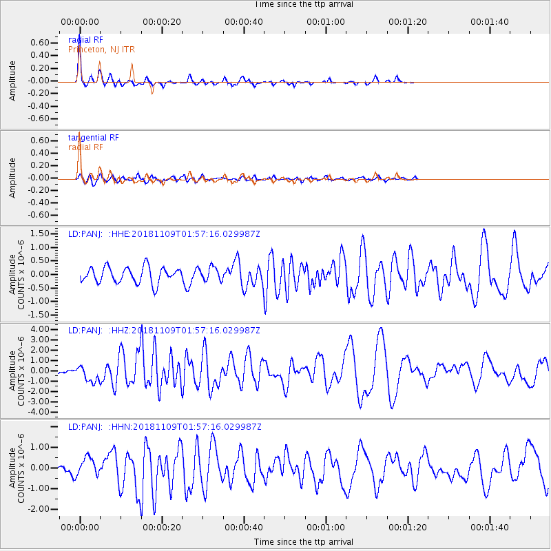
Signal To Noise
| Channel | StoN | STA | LTA |
| LD:PANJ: :HHZ:20181109T01:57:16.029987Z | 3.5333498 | 8.131626E-7 | 2.3013929E-7 |
| LD:PANJ: :HHN:20181109T01:57:16.029987Z | 2.323658 | 4.4309706E-7 | 1.9068946E-7 |
| LD:PANJ: :HHE:20181109T01:57:16.029987Z | 0.83222127 | 2.407095E-7 | 2.8923736E-7 |
| Arrivals |
| Ps | 3.0 SECOND |
| PpPs | 7.6 SECOND |
| PsPs/PpSs | 11 SECOND |


