You are here: Home > Network List > LD - Lamont-Doherty Cooperative Seismographic Network Stations List
> Station TRNY Table Rock, Ramapo, NY > Earthquake Result Viewer
TRNY Table Rock, Ramapo, NY - Earthquake Result Viewer
| Earthquake location: |
Jan Mayen Island Region |
| Earthquake latitude/longitude: |
71.6/-11.2 |
| Earthquake time(UTC): |
2018/11/09 (313) 01:49:40 GMT |
| Earthquake Depth: |
10 km |
| Earthquake Magnitude: |
6.8 Mww |
| Earthquake Catalog/Contributor: |
NEIC PDE/us |
|
| Network: |
LD Lamont-Doherty Cooperative Seismographic Network |
| Station: |
TRNY Table Rock, Ramapo, NY |
| Lat/Lon: |
41.15 N/74.22 W |
| Elevation: |
270 m |
|
| Distance: |
43.1 deg |
| Az: |
260.099 deg |
| Baz: |
24.439 deg |
| Ray Param: |
0.072783515 |
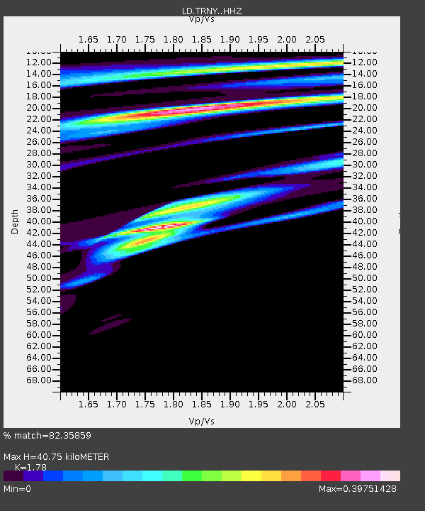
| Estimated Moho Depth: |
40.75 km |
| Estimated Crust Vp/Vs: |
1.78 |
| Assumed Crust Vp: |
6.283 km/s |
| Estimated Crust Vs: |
3.53 km/s |
| Estimated Crust Poisson's Ratio: |
0.27 |
|
| Radial Match: |
82.35859 % |
| Radial Bump: |
362 |
| Transverse Match: |
82.358574 % |
| Transverse Bump: |
362 |
| SOD ConfigId: |
13570011 |
| Insert Time: |
2019-05-01 18:33:18.926 +0000 |
| GWidth: |
2.5 |
| Max Bumps: |
400 |
| Tol: |
0.001 |
|

Signal To Noise
| Channel | StoN | STA | LTA |
| LD:TRNY: :HHZ:20181109T01:57:09.205005Z | 2.1019778 | 5.709392E-7 | 2.7161997E-7 |
| LD:TRNY: :HHN:20181109T01:57:09.205005Z | 0.97621423 | 2.8426908E-7 | 2.9119536E-7 |
| $trig.getChannelId() | $trig.getValue() | $trig.getSTA() | $trig.getLTA() |
| Arrivals |
| Ps | 5.4 SECOND |
| PpPs | 17 SECOND |
| PsPs/PpSs | 22 SECOND |


