You are here: Home > Network List > TA - USArray Transportable Network (new EarthScope stations) Stations List
> Station G04A Mulino, OR, USA > Earthquake Result Viewer
G04A Mulino, OR, USA - Earthquake Result Viewer
| Earthquake location: |
Near Coast Of Peru |
| Earthquake latitude/longitude: |
-13.4/-76.6 |
| Earthquake time(UTC): |
2007/08/15 (227) 23:40:57 GMT |
| Earthquake Depth: |
39 km |
| Earthquake Magnitude: |
6.7 MB, 7.9 MS, 8.0 MW, 7.5 ME |
| Earthquake Catalog/Contributor: |
WHDF/NEIC |
|
| Network: |
TA USArray Transportable Network (new EarthScope stations) |
| Station: |
G04A Mulino, OR, USA |
| Lat/Lon: |
45.21 N/122.48 W |
| Elevation: |
273 m |
|
| Distance: |
71.6 deg |
| Az: |
327.661 deg |
| Baz: |
132.576 deg |
| Ray Param: |
0.0541796 |
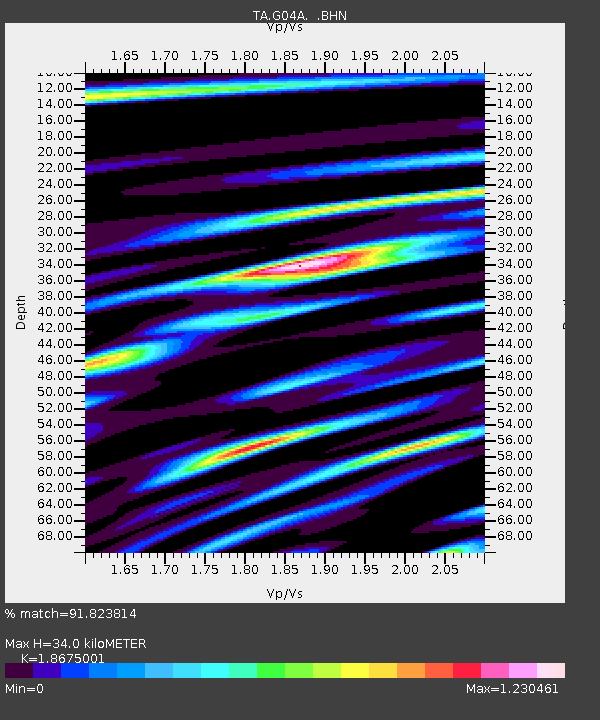
| Estimated Moho Depth: |
34.0 km |
| Estimated Crust Vp/Vs: |
1.87 |
| Assumed Crust Vp: |
6.566 km/s |
| Estimated Crust Vs: |
3.516 km/s |
| Estimated Crust Poisson's Ratio: |
0.30 |
|
| Radial Match: |
91.823814 % |
| Radial Bump: |
400 |
| Transverse Match: |
68.51413 % |
| Transverse Bump: |
400 |
| SOD ConfigId: |
2564 |
| Insert Time: |
2010-03-06 17:40:50.737 +0000 |
| GWidth: |
2.5 |
| Max Bumps: |
400 |
| Tol: |
0.001 |
|

Signal To Noise
| Channel | StoN | STA | LTA |
| TA:G04A: :BHN:20070815T23:51:44.074021Z | 6.561656 | 8.211662E-7 | 1.2514619E-7 |
| TA:G04A: :BHE:20070815T23:51:44.074021Z | 5.332342 | 9.4186936E-7 | 1.7663332E-7 |
| TA:G04A: :BHZ:20070815T23:51:44.074021Z | 18.1535 | 2.798779E-6 | 1.5417298E-7 |
| Arrivals |
| Ps | 4.7 SECOND |
| PpPs | 14 SECOND |
| PsPs/PpSs | 19 SECOND |


