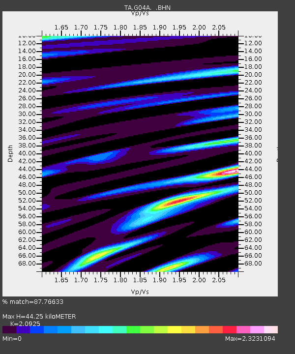
G04A Mulino, OR, USA - Earthquake Result Viewer

Earthquake location: Andreanof Islands, Aleutian Is.
Earthquake latitude/longitude: 50.3/-177.5
Earthquake time(UTC): 2007/08/15 (227) 20:22:11 GMT
Earthquake Depth: 9.0 km
Earthquake Magnitude: 6.3 MB, 6.2 MS, 6.4 MW, 5.9 ML
Earthquake Catalog/Contributor: WHDF/NEIC
Network: TA USArray Transportable Network (new EarthScope stations)
Station: G04A Mulino, OR, USA
Lat/Lon: 45.21 N/122.48 W
Elevation: 273 m
Distance: 36.6 deg
Az: 76.169 deg
Baz: 298.303 deg
Ray Param: 0.07656897
Estimated Moho Depth: 44.25 km
Estimated Crust Vp/Vs: 2.09
Assumed Crust Vp: 6.566 km/s
Estimated Crust Vs: 3.138 km/s
Estimated Crust Poisson's Ratio: 0.35
Radial Match: 87.76633 %
Radial Bump: 400
Transverse Match: 64.832375 %
Transverse Bump: 400
SOD ConfigId: 2564
Insert Time: 2010-03-06 17:40:52.203 +0000
GWidth: 2.5
Max Bumps: 400
Tol: 0.001

Signal To Noise

ChannelStoNSTALTA
TA:G04A: :BHN:20070815T20:28:47.048009Z6.1892258.073577E-71.3044568E-7
TA:G04A: :BHE:20070815T20:28:47.048009Z6.7745871.4099484E-62.0812313E-7
TA:G04A: :BHZ:20070815T20:28:47.048009Z23.074322.5552968E-61.1074202E-7
Arrivals
Ps7.9 SECOND
PpPs20 SECOND
PsPs/PpSs27 SECOND