You are here: Home > Network List > N4 - Central and EAstern US Network Stations List
> Station K30B Basset, NE, USA > Earthquake Result Viewer
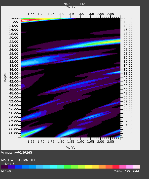
K30B Basset, NE, USA - Earthquake Result Viewer
| Earthquake location: |
Jan Mayen Island Region |
| Earthquake latitude/longitude: |
71.6/-11.2 |
| Earthquake time(UTC): |
2018/11/09 (313) 01:49:40 GMT |
| Earthquake Depth: |
10 km |
| Earthquake Magnitude: |
6.8 Mww |
| Earthquake Catalog/Contributor: |
NEIC PDE/us |
|
| Network: |
N4 Central and EAstern US Network |
| Station: |
K30B Basset, NE, USA |
| Lat/Lon: |
42.67 N/99.61 W |
| Elevation: |
712 m |
|
| Distance: |
49.7 deg |
| Az: |
284.77 deg |
| Baz: |
24.575 deg |
| Ray Param: |
0.068550155 |
| Estimated Moho Depth: |
11.0 km |
| Estimated Crust Vp/Vs: |
1.60 |
| Assumed Crust Vp: |
6.53 km/s |
| Estimated Crust Vs: |
4.082 km/s |
| Estimated Crust Poisson's Ratio: |
0.18 |
|
| Radial Match: |
90.39265 % |
| Radial Bump: |
350 |
| Transverse Match: |
79.67542 % |
| Transverse Bump: |
400 |
| SOD ConfigId: |
13570011 |
| Insert Time: |
2019-05-01 18:34:38.698 +0000 |
| GWidth: |
2.5 |
| Max Bumps: |
400 |
| Tol: |
0.001 |
|

Signal To Noise
| Channel | StoN | STA | LTA |
| N4:K30B: :HHZ:20181109T01:58:00.93999Z | 7.47396 | 1.0704139E-6 | 1.4321911E-7 |
| N4:K30B: :HHN:20181109T01:58:00.93999Z | 1.8626672 | 8.134207E-7 | 4.3669672E-7 |
| N4:K30B: :HHE:20181109T01:58:00.93999Z | 3.7209737 | 6.6729154E-7 | 1.7933252E-7 |
| Arrivals |
| Ps | 1.1 SECOND |
| PpPs | 4.1 SECOND |
| PsPs/PpSs | 5.2 SECOND |


