You are here: Home > Network List > N4 - Central and EAstern US Network Stations List
> Station L64A Middleborough, MA, USA > Earthquake Result Viewer
L64A Middleborough, MA, USA - Earthquake Result Viewer
| Earthquake location: |
Jan Mayen Island Region |
| Earthquake latitude/longitude: |
71.6/-11.2 |
| Earthquake time(UTC): |
2018/11/09 (313) 01:49:40 GMT |
| Earthquake Depth: |
10 km |
| Earthquake Magnitude: |
6.8 Mww |
| Earthquake Catalog/Contributor: |
NEIC PDE/us |
|
| Network: |
N4 Central and EAstern US Network |
| Station: |
L64A Middleborough, MA, USA |
| Lat/Lon: |
41.94 N/70.84 W |
| Elevation: |
17 m |
|
| Distance: |
41.3 deg |
| Az: |
257.142 deg |
| Baz: |
24.485 deg |
| Ray Param: |
0.073874906 |
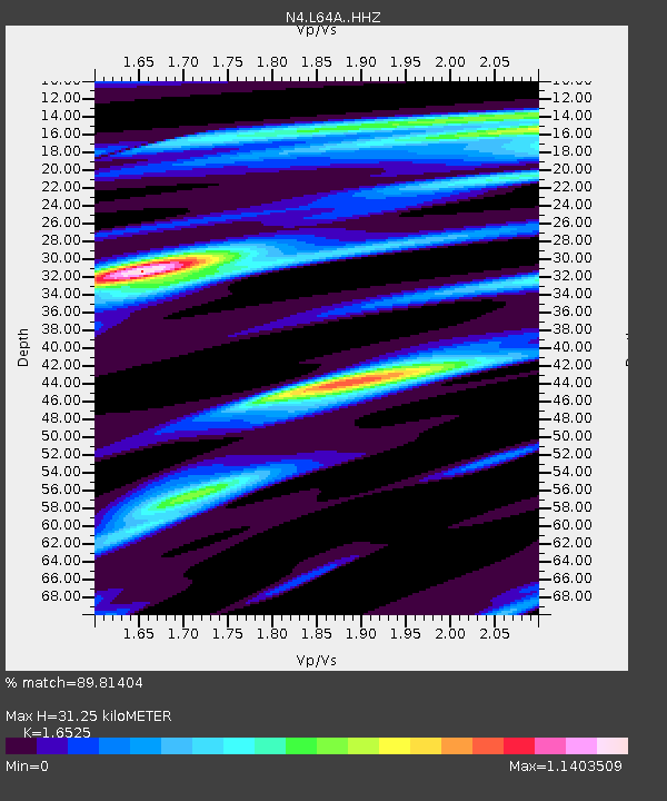
| Estimated Moho Depth: |
31.25 km |
| Estimated Crust Vp/Vs: |
1.65 |
| Assumed Crust Vp: |
6.472 km/s |
| Estimated Crust Vs: |
3.916 km/s |
| Estimated Crust Poisson's Ratio: |
0.21 |
|
| Radial Match: |
89.81404 % |
| Radial Bump: |
311 |
| Transverse Match: |
42.88043 % |
| Transverse Bump: |
372 |
| SOD ConfigId: |
13570011 |
| Insert Time: |
2019-05-01 18:34:44.509 +0000 |
| GWidth: |
2.5 |
| Max Bumps: |
400 |
| Tol: |
0.001 |
|

Signal To Noise
| Channel | StoN | STA | LTA |
| N4:L64A: :HHZ:20181109T01:56:54.770007Z | 2.2935183 | 8.4955104E-7 | 3.704139E-7 |
| N4:L64A: :HHN:20181109T01:56:54.770007Z | 2.0290644 | 5.147456E-7 | 2.5368618E-7 |
| N4:L64A: :HHE:20181109T01:56:54.770007Z | 0.8915565 | 3.4064786E-7 | 3.8208216E-7 |
| Arrivals |
| Ps | 3.4 SECOND |
| PpPs | 12 SECOND |
| PsPs/PpSs | 15 SECOND |


