You are here: Home > Network List > N4 - Central and EAstern US Network Stations List
> Station P61A Hammonton, NJ, USA > Earthquake Result Viewer
P61A Hammonton, NJ, USA - Earthquake Result Viewer
| Earthquake location: |
Jan Mayen Island Region |
| Earthquake latitude/longitude: |
71.6/-11.2 |
| Earthquake time(UTC): |
2018/11/09 (313) 01:49:40 GMT |
| Earthquake Depth: |
10 km |
| Earthquake Magnitude: |
6.8 Mww |
| Earthquake Catalog/Contributor: |
NEIC PDE/us |
|
| Network: |
N4 Central and EAstern US Network |
| Station: |
P61A Hammonton, NJ, USA |
| Lat/Lon: |
39.67 N/74.79 W |
| Elevation: |
22 m |
|
| Distance: |
44.6 deg |
| Az: |
259.802 deg |
| Baz: |
23.858 deg |
| Ray Param: |
0.07181885 |
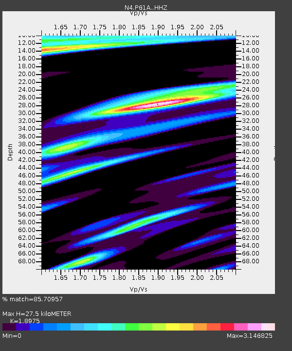
| Estimated Moho Depth: |
27.5 km |
| Estimated Crust Vp/Vs: |
1.90 |
| Assumed Crust Vp: |
6.287 km/s |
| Estimated Crust Vs: |
3.314 km/s |
| Estimated Crust Poisson's Ratio: |
0.31 |
|
| Radial Match: |
85.70957 % |
| Radial Bump: |
400 |
| Transverse Match: |
63.331856 % |
| Transverse Bump: |
400 |
| SOD ConfigId: |
13570011 |
| Insert Time: |
2019-05-01 18:34:54.804 +0000 |
| GWidth: |
2.5 |
| Max Bumps: |
400 |
| Tol: |
0.001 |
|

Signal To Noise
| Channel | StoN | STA | LTA |
| N4:P61A: :HHZ:20181109T01:57:21.390002Z | 2.3188164 | 7.6441074E-7 | 3.2965556E-7 |
| N4:P61A: :HHN:20181109T01:57:21.390002Z | 0.4088297 | 3.5661165E-7 | 8.7227437E-7 |
| N4:P61A: :HHE:20181109T01:57:21.390002Z | 1.130139 | 1.0143114E-6 | 8.9751023E-7 |
| Arrivals |
| Ps | 4.2 SECOND |
| PpPs | 12 SECOND |
| PsPs/PpSs | 16 SECOND |


