You are here: Home > Network List > TA - USArray Transportable Network (new EarthScope stations) Stations List
> Station G04A Mulino, OR, USA > Earthquake Result Viewer
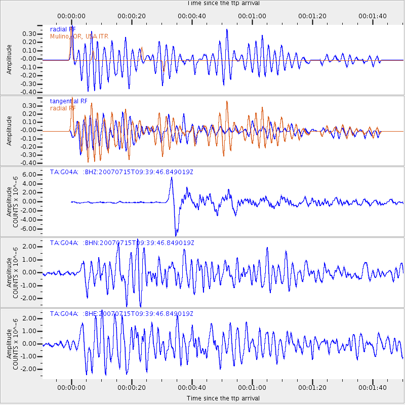
G04A Mulino, OR, USA - Earthquake Result Viewer

| Earthquake location: |
Vanuatu Islands |
| Earthquake latitude/longitude: |
-15.4/168.6 |
| Earthquake time(UTC): |
2007/07/15 (196) 09:27:34 GMT |
| Earthquake Depth: |
8.0 km |
| Earthquake Magnitude: |
6.0 MB, 5.8 MS, 6.1 MW, 6.0 MW |
| Earthquake Catalog/Contributor: |
WHDF/NEIC |
|
| Network: |
TA USArray Transportable Network (new EarthScope stations) |
| Station: |
G04A Mulino, OR, USA |
| Lat/Lon: |
45.21 N/122.48 W |
| Elevation: |
273 m |
|
| Distance: |
86.6 deg |
| Az: |
41.36 deg |
| Baz: |
244.377 deg |
| Ray Param: |
0.04391542 |
| Estimated Moho Depth: |
65.0 km |
| Estimated Crust Vp/Vs: |
1.68 |
| Assumed Crust Vp: |
6.566 km/s |
| Estimated Crust Vs: |
3.92 km/s |
| Estimated Crust Poisson's Ratio: |
0.22 |
|
| Radial Match: |
86.42569 % |
| Radial Bump: |
400 |
| Transverse Match: |
75.198235 % |
| Transverse Bump: |
400 |
| SOD ConfigId: |
2564 |
| Insert Time: |
2010-03-06 17:40:57.841 +0000 |
| GWidth: |
2.5 |
| Max Bumps: |
400 |
| Tol: |
0.001 |
|
Signal To Noise
| Channel | StoN | STA | LTA |
| TA:G04A: :BHN:20070715T09:39:46.849019Z | 3.807048 | 4.0578703E-7 | 1.0658837E-7 |
| TA:G04A: :BHE:20070715T09:39:46.849019Z | 6.280822 | 8.1596073E-7 | 1.2991305E-7 |
| TA:G04A: :BHZ:20070715T09:39:46.849019Z | 36.368782 | 2.9240214E-6 | 8.039922E-8 |
| Arrivals |
| Ps | 6.9 SECOND |
| PpPs | 26 SECOND |
| PsPs/PpSs | 33 SECOND |


