You are here: Home > Network List > TA - USArray Transportable Network (new EarthScope stations) Stations List
> Station G04A Mulino, OR, USA > Earthquake Result Viewer
G04A Mulino, OR, USA - Earthquake Result Viewer
| Earthquake location: |
Solomon Islands |
| Earthquake latitude/longitude: |
-7.3/155.7 |
| Earthquake time(UTC): |
2007/04/01 (091) 21:11:33 GMT |
| Earthquake Depth: |
10 km |
| Earthquake Magnitude: |
6.3 MB |
| Earthquake Catalog/Contributor: |
WHDF/NEIC |
|
| Network: |
TA USArray Transportable Network (new EarthScope stations) |
| Station: |
G04A Mulino, OR, USA |
| Lat/Lon: |
45.21 N/122.48 W |
| Elevation: |
273 m |
|
| Distance: |
89.4 deg |
| Az: |
44.405 deg |
| Baz: |
259.069 deg |
| Ray Param: |
0.041895963 |
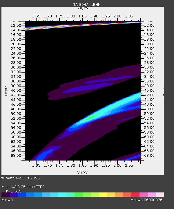
| Estimated Moho Depth: |
13.25 km |
| Estimated Crust Vp/Vs: |
1.62 |
| Assumed Crust Vp: |
6.566 km/s |
| Estimated Crust Vs: |
4.066 km/s |
| Estimated Crust Poisson's Ratio: |
0.19 |
|
| Radial Match: |
93.287895 % |
| Radial Bump: |
354 |
| Transverse Match: |
67.25828 % |
| Transverse Bump: |
377 |
| SOD ConfigId: |
2564 |
| Insert Time: |
2010-03-06 17:41:01.858 +0000 |
| GWidth: |
2.5 |
| Max Bumps: |
400 |
| Tol: |
0.001 |
|

Signal To Noise
| Channel | StoN | STA | LTA |
| TA:G04A: :BHN:20070401T21:23:58.275Z | 2.791251 | 3.135878E-5 | 1.123467E-5 |
| TA:G04A: :BHE:20070401T21:23:58.275Z | 2.708062 | 8.193747E-5 | 3.0256868E-5 |
| TA:G04A: :BHZ:20070401T21:23:58.275Z | 1.7132083 | 5.6921486E-5 | 3.3225082E-5 |
| Arrivals |
| Ps | 1.3 SECOND |
| PpPs | 5.2 SECOND |
| PsPs/PpSs | 6.4 SECOND |


