You are here: Home > Network List > TA - USArray Transportable Network (new EarthScope stations) Stations List
> Station G04A Mulino, OR, USA > Earthquake Result Viewer
G04A Mulino, OR, USA - Earthquake Result Viewer
| Earthquake location: |
South Of Panama |
| Earthquake latitude/longitude: |
4.6/-78.5 |
| Earthquake time(UTC): |
2007/03/18 (077) 02:11:05 GMT |
| Earthquake Depth: |
8.0 km |
| Earthquake Magnitude: |
6.4 MB, 5.7 MS, 6.2 MW, 6.1 MW |
| Earthquake Catalog/Contributor: |
WHDF/NEIC |
|
| Network: |
TA USArray Transportable Network (new EarthScope stations) |
| Station: |
G04A Mulino, OR, USA |
| Lat/Lon: |
45.21 N/122.48 W |
| Elevation: |
273 m |
|
| Distance: |
55.7 deg |
| Az: |
323.552 deg |
| Baz: |
123.101 deg |
| Ray Param: |
0.06461659 |
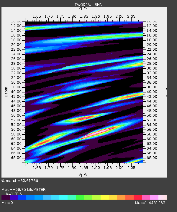
| Estimated Moho Depth: |
56.75 km |
| Estimated Crust Vp/Vs: |
1.91 |
| Assumed Crust Vp: |
6.566 km/s |
| Estimated Crust Vs: |
3.429 km/s |
| Estimated Crust Poisson's Ratio: |
0.31 |
|
| Radial Match: |
80.61766 % |
| Radial Bump: |
400 |
| Transverse Match: |
76.125435 % |
| Transverse Bump: |
400 |
| SOD ConfigId: |
2564 |
| Insert Time: |
2010-03-06 17:41:04.948 +0000 |
| GWidth: |
2.5 |
| Max Bumps: |
400 |
| Tol: |
0.001 |
|
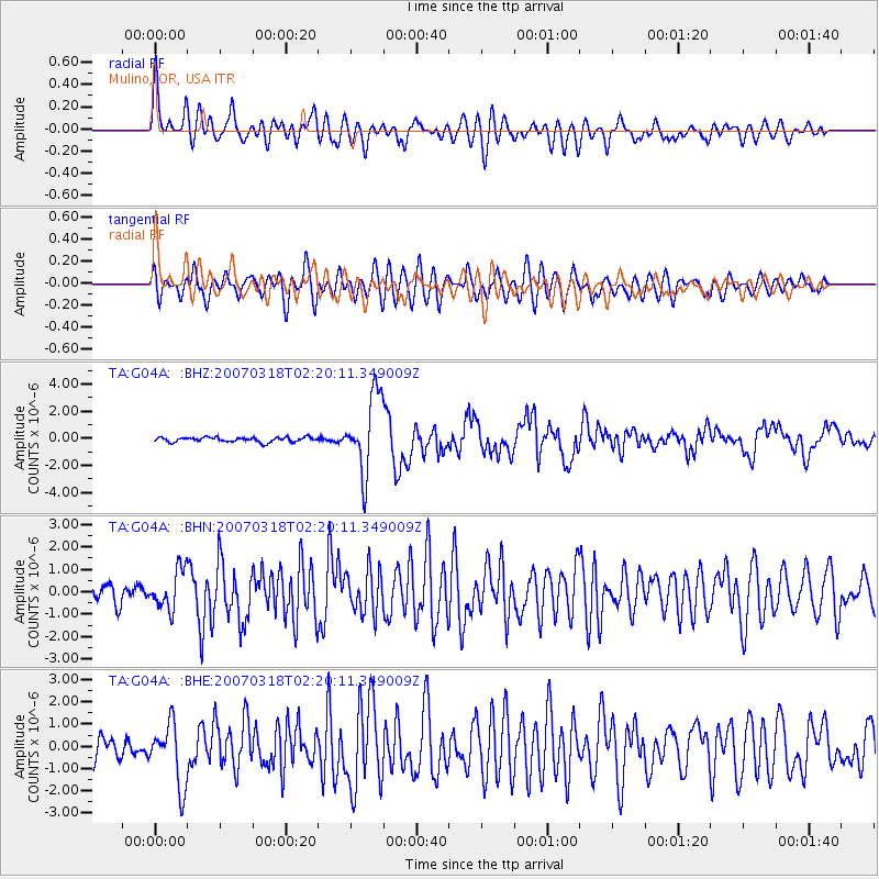
Signal To Noise
| Channel | StoN | STA | LTA |
| TA:G04A: :BHN:20070318T02:20:11.349009Z | 2.2647326 | 8.746691E-7 | 3.86213E-7 |
| TA:G04A: :BHE:20070318T02:20:11.349009Z | 2.96435 | 1.3949898E-6 | 4.7058873E-7 |
| TA:G04A: :BHZ:20070318T02:20:11.349009Z | 16.44817 | 2.8334102E-6 | 1.7226296E-7 |
| Arrivals |
| Ps | 8.3 SECOND |
| PpPs | 24 SECOND |
| PsPs/PpSs | 32 SECOND |


