You are here: Home > Network List > TA - USArray Transportable Network (new EarthScope stations) Stations List
> Station G04A Mulino, OR, USA > Earthquake Result Viewer
G04A Mulino, OR, USA - Earthquake Result Viewer
| Earthquake location: |
Eastern Siberia, Russia |
| Earthquake latitude/longitude: |
60.5/167.5 |
| Earthquake time(UTC): |
2006/04/29 (119) 16:58:06 GMT |
| Earthquake Depth: |
11 km |
| Earthquake Magnitude: |
6.4 MB, 6.6 MS, 6.6 MW, 6.4 MW |
| Earthquake Catalog/Contributor: |
WHDF/NEIC |
|
| Network: |
TA USArray Transportable Network (new EarthScope stations) |
| Station: |
G04A Mulino, OR, USA |
| Lat/Lon: |
45.21 N/122.48 W |
| Elevation: |
273 m |
|
| Distance: |
42.8 deg |
| Az: |
78.089 deg |
| Baz: |
316.747 deg |
| Ray Param: |
0.072979234 |
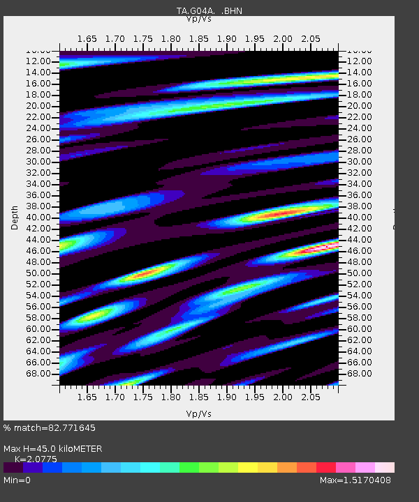
| Estimated Moho Depth: |
45.0 km |
| Estimated Crust Vp/Vs: |
2.08 |
| Assumed Crust Vp: |
6.566 km/s |
| Estimated Crust Vs: |
3.161 km/s |
| Estimated Crust Poisson's Ratio: |
0.35 |
|
| Radial Match: |
82.771645 % |
| Radial Bump: |
400 |
| Transverse Match: |
67.81681 % |
| Transverse Bump: |
400 |
| SOD ConfigId: |
2669 |
| Insert Time: |
2010-03-06 17:41:12.465 +0000 |
| GWidth: |
2.5 |
| Max Bumps: |
400 |
| Tol: |
0.001 |
|
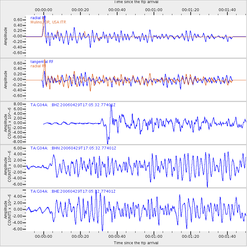
Signal To Noise
| Channel | StoN | STA | LTA |
| TA:G04A: :BHN:20060429T17:05:32.77401Z | 1.6622245 | 5.789399E-7 | 3.4829222E-7 |
| TA:G04A: :BHE:20060429T17:05:32.77401Z | 1.8093776 | 6.6713056E-7 | 3.6870722E-7 |
| TA:G04A: :BHZ:20060429T17:05:32.77401Z | 9.451156 | 2.3036157E-6 | 2.4373904E-7 |
| Arrivals |
| Ps | 7.8 SECOND |
| PpPs | 20 SECOND |
| PsPs/PpSs | 28 SECOND |


