You are here: Home > Network List > TA - USArray Transportable Network (new EarthScope stations) Stations List
> Station G04A Mulino, OR, USA > Earthquake Result Viewer
G04A Mulino, OR, USA - Earthquake Result Viewer
| Earthquake location: |
Eastern Siberia, Russia |
| Earthquake latitude/longitude: |
60.9/167.1 |
| Earthquake time(UTC): |
2006/04/20 (110) 23:25:02 GMT |
| Earthquake Depth: |
22 km |
| Earthquake Magnitude: |
6.8 MB, 7.6 MS, 7.6 MW, 7.3 MW |
| Earthquake Catalog/Contributor: |
WHDF/NEIC |
|
| Network: |
TA USArray Transportable Network (new EarthScope stations) |
| Station: |
G04A Mulino, OR, USA |
| Lat/Lon: |
45.21 N/122.48 W |
| Elevation: |
273 m |
|
| Distance: |
42.9 deg |
| Az: |
78.249 deg |
| Baz: |
317.472 deg |
| Ray Param: |
0.07287968 |
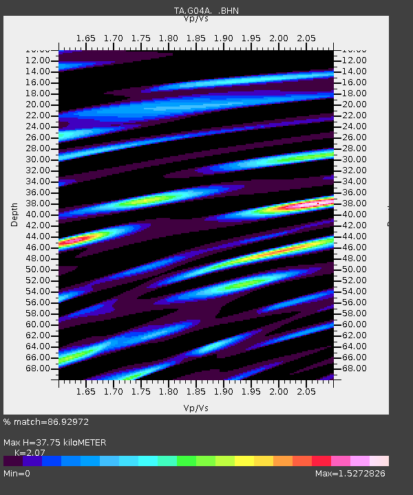
| Estimated Moho Depth: |
37.75 km |
| Estimated Crust Vp/Vs: |
2.07 |
| Assumed Crust Vp: |
6.566 km/s |
| Estimated Crust Vs: |
3.172 km/s |
| Estimated Crust Poisson's Ratio: |
0.35 |
|
| Radial Match: |
86.92972 % |
| Radial Bump: |
400 |
| Transverse Match: |
82.75863 % |
| Transverse Bump: |
400 |
| SOD ConfigId: |
2669 |
| Insert Time: |
2010-03-06 17:41:16.397 +0000 |
| GWidth: |
2.5 |
| Max Bumps: |
400 |
| Tol: |
0.001 |
|
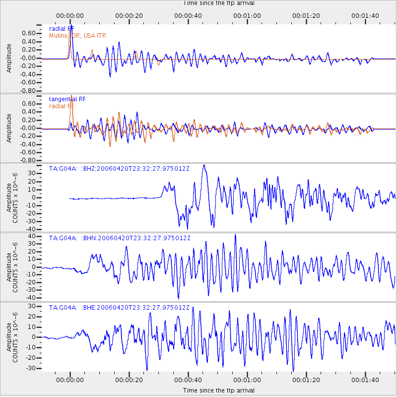
Signal To Noise
| Channel | StoN | STA | LTA |
| TA:G04A: :BHN:20060420T23:32:27.975012Z | 7.8601274 | 4.352083E-6 | 5.5369117E-7 |
| TA:G04A: :BHE:20060420T23:32:27.975012Z | 6.130978 | 3.8840435E-6 | 6.3351126E-7 |
| TA:G04A: :BHZ:20060420T23:32:27.975012Z | 22.002289 | 1.0263831E-5 | 4.664892E-7 |
| Arrivals |
| Ps | 6.5 SECOND |
| PpPs | 17 SECOND |
| PsPs/PpSs | 23 SECOND |


