You are here: Home > Network List > O2 - Oklahoma Consolidated Temporary Seismic Networks Stations List
> Station DRUM Drumwright, Oklahoma, USA > Earthquake Result Viewer
DRUM Drumwright, Oklahoma, USA - Earthquake Result Viewer
| Earthquake location: |
Jan Mayen Island Region |
| Earthquake latitude/longitude: |
71.6/-11.2 |
| Earthquake time(UTC): |
2018/11/09 (313) 01:49:40 GMT |
| Earthquake Depth: |
10 km |
| Earthquake Magnitude: |
6.8 Mww |
| Earthquake Catalog/Contributor: |
NEIC PDE/us |
|
| Network: |
O2 Oklahoma Consolidated Temporary Seismic Networks |
| Station: |
DRUM Drumwright, Oklahoma, USA |
| Lat/Lon: |
35.92 N/96.61 W |
| Elevation: |
296 m |
|
| Distance: |
54.9 deg |
| Az: |
278.648 deg |
| Baz: |
22.726 deg |
| Ray Param: |
0.06513676 |
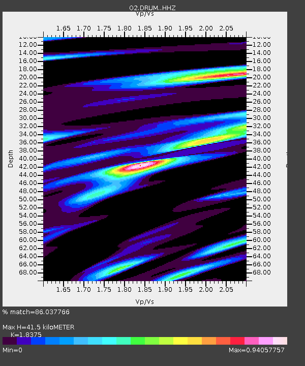
| Estimated Moho Depth: |
41.5 km |
| Estimated Crust Vp/Vs: |
1.84 |
| Assumed Crust Vp: |
6.426 km/s |
| Estimated Crust Vs: |
3.497 km/s |
| Estimated Crust Poisson's Ratio: |
0.29 |
|
| Radial Match: |
86.037766 % |
| Radial Bump: |
400 |
| Transverse Match: |
54.89721 % |
| Transverse Bump: |
400 |
| SOD ConfigId: |
13570011 |
| Insert Time: |
2019-05-01 18:36:12.562 +0000 |
| GWidth: |
2.5 |
| Max Bumps: |
400 |
| Tol: |
0.001 |
|

Signal To Noise
| Channel | StoN | STA | LTA |
| O2:DRUM: :HHZ:20181109T01:58:39.83501Z | 2.6608584 | 6.079392E-7 | 2.2847485E-7 |
| O2:DRUM: :HH1:20181109T01:58:39.83501Z | 2.3283598 | 4.41276E-7 | 1.8952225E-7 |
| O2:DRUM: :HH2:20181109T01:58:39.83501Z | 0.77202064 | 2.6317903E-7 | 3.4089635E-7 |
| Arrivals |
| Ps | 5.7 SECOND |
| PpPs | 17 SECOND |
| PsPs/PpSs | 23 SECOND |


