You are here: Home > Network List > TA - USArray Transportable Network (new EarthScope stations) Stations List
> Station G04A Mulino, OR, USA > Earthquake Result Viewer
G04A Mulino, OR, USA - Earthquake Result Viewer

| Earthquake location: |
Kuril Islands |
| Earthquake latitude/longitude: |
46.5/153.2 |
| Earthquake time(UTC): |
2006/10/01 (274) 09:06:02 GMT |
| Earthquake Depth: |
19 km |
| Earthquake Magnitude: |
6.1 MB, 6.4 MS, 6.6 MW, 6.5 MW |
| Earthquake Catalog/Contributor: |
WHDF/NEIC |
|
| Network: |
TA USArray Transportable Network (new EarthScope stations) |
| Station: |
G04A Mulino, OR, USA |
| Lat/Lon: |
45.21 N/122.48 W |
| Elevation: |
273 m |
|
| Distance: |
56.0 deg |
| Az: |
58.095 deg |
| Baz: |
303.904 deg |
| Ray Param: |
0.06443459 |
| Estimated Moho Depth: |
50.5 km |
| Estimated Crust Vp/Vs: |
1.98 |
| Assumed Crust Vp: |
6.566 km/s |
| Estimated Crust Vs: |
3.32 km/s |
| Estimated Crust Poisson's Ratio: |
0.33 |
|
| Radial Match: |
88.42928 % |
| Radial Bump: |
400 |
| Transverse Match: |
74.26123 % |
| Transverse Bump: |
400 |
| SOD ConfigId: |
2665 |
| Insert Time: |
2010-03-06 17:41:22.418 +0000 |
| GWidth: |
2.5 |
| Max Bumps: |
400 |
| Tol: |
0.001 |
|
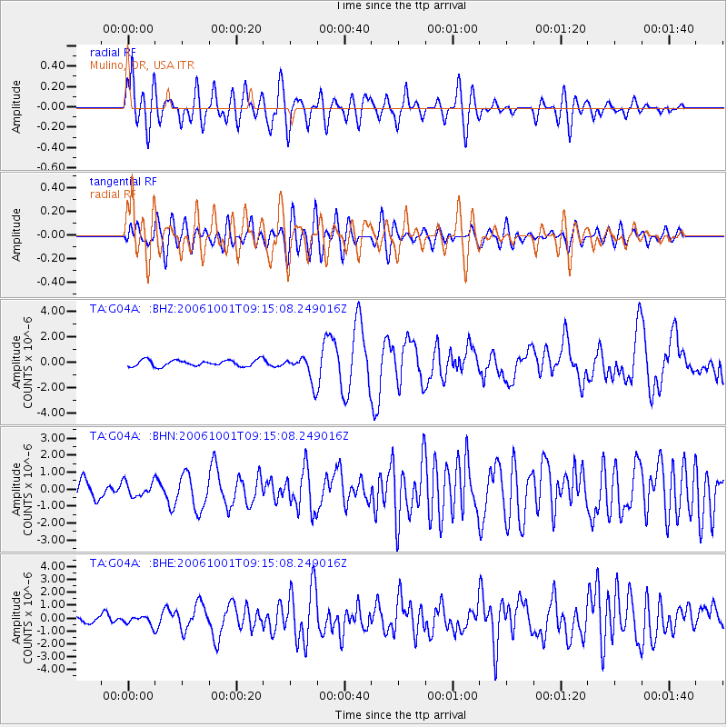
Signal To Noise
| Channel | StoN | STA | LTA |
| TA:G04A: :BHN:20061001T09:15:08.249016Z | 1.0665444 | 4.2560916E-7 | 3.9905433E-7 |
| TA:G04A: :BHE:20061001T09:15:08.249016Z | 1.0205914 | 3.4271469E-7 | 3.358001E-7 |
| TA:G04A: :BHZ:20061001T09:15:08.249016Z | 4.322293 | 1.0611554E-6 | 2.4550752E-7 |
| Arrivals |
| Ps | 7.9 SECOND |
| PpPs | 22 SECOND |
| PsPs/PpSs | 30 SECOND |


