You are here: Home > Network List > TS - TERRAscope (Southern California Seismic Network) Stations List
> Station BAR Barrett Dam, California, USA > Earthquake Result Viewer
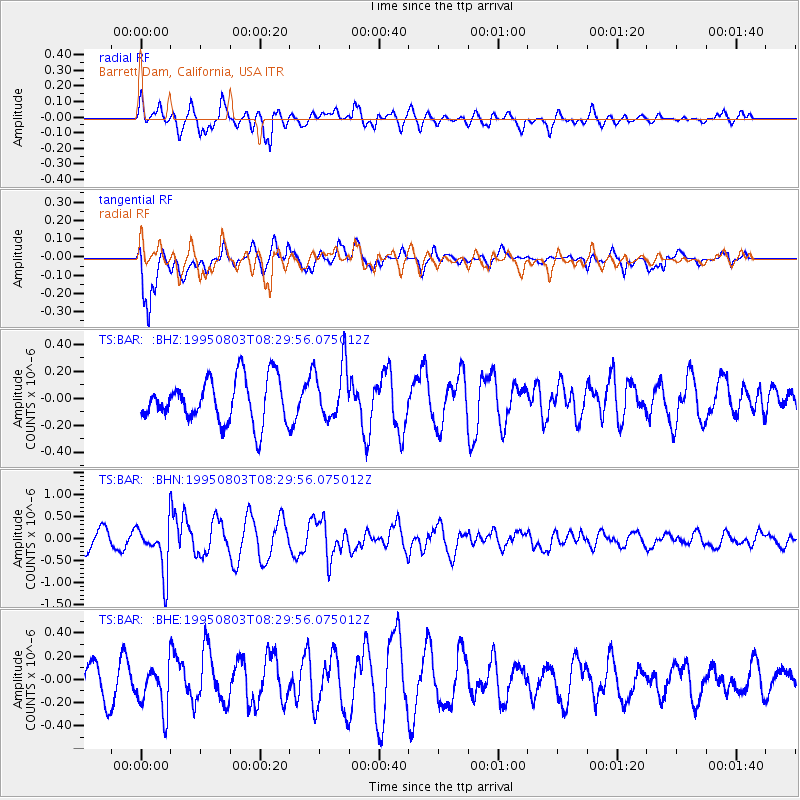
BAR Barrett Dam, California, USA - Earthquake Result Viewer
*The percent match for this event was below the threshold and hence no stack was calculated.
| Earthquake location: |
Chile-Argentina Border Region |
| Earthquake latitude/longitude: |
-28.3/-69.2 |
| Earthquake time(UTC): |
1995/08/03 (215) 08:18:53 GMT |
| Earthquake Depth: |
104 km |
| Earthquake Magnitude: |
5.9 MB, 5.8 UNKNOWN, 5.9 MW |
| Earthquake Catalog/Contributor: |
WHDF/NEIC |
|
| Network: |
TS TERRAscope (Southern California Seismic Network) |
| Station: |
BAR Barrett Dam, California, USA |
| Lat/Lon: |
32.68 N/116.67 W |
| Elevation: |
548 m |
|
| Distance: |
75.6 deg |
| Az: |
320.084 deg |
| Baz: |
137.883 deg |
| Ray Param: |
$rayparam |
*The percent match for this event was below the threshold and hence was not used in the summary stack. |
|
| Radial Match: |
61.76958 % |
| Radial Bump: |
400 |
| Transverse Match: |
80.416466 % |
| Transverse Bump: |
400 |
| SOD ConfigId: |
4480 |
| Insert Time: |
2010-02-26 14:00:17.093 +0000 |
| GWidth: |
2.5 |
| Max Bumps: |
400 |
| Tol: |
0.001 |
|
Signal To Noise
| Channel | StoN | STA | LTA |
| TS:BAR: :BHN:19950803T08:29:56.075012Z | 3.079663 | 5.6867117E-7 | 1.8465369E-7 |
| TS:BAR: :BHE:19950803T08:29:56.075012Z | 1.3695667 | 1.9930123E-7 | 1.4552137E-7 |
| TS:BAR: :BHZ:19950803T08:29:56.075012Z | 1.252089 | 2.0203844E-7 | 1.6136109E-7 |
| Arrivals |
| Ps | |
| PpPs | |
| PsPs/PpSs | |


