You are here: Home > Network List > TA - USArray Transportable Network (new EarthScope stations) Stations List
> Station G04A Mulino, OR, USA > Earthquake Result Viewer
G04A Mulino, OR, USA - Earthquake Result Viewer
| Earthquake location: |
Off Coast Of Central Chile |
| Earthquake latitude/longitude: |
-28.7/-72.5 |
| Earthquake time(UTC): |
2006/07/16 (197) 11:42:41 GMT |
| Earthquake Depth: |
10 km |
| Earthquake Magnitude: |
5.9 MB, 5.7 MS, 6.2 MW, 6.2 MW |
| Earthquake Catalog/Contributor: |
WHDF/NEIC |
|
| Network: |
TA USArray Transportable Network (new EarthScope stations) |
| Station: |
G04A Mulino, OR, USA |
| Lat/Lon: |
45.21 N/122.48 W |
| Elevation: |
273 m |
|
| Distance: |
86.5 deg |
| Az: |
327.176 deg |
| Baz: |
137.661 deg |
| Ray Param: |
0.04403143 |
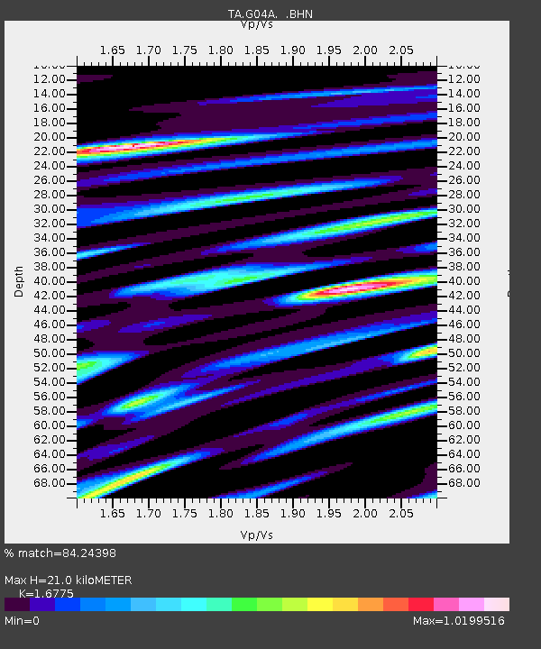
| Estimated Moho Depth: |
21.0 km |
| Estimated Crust Vp/Vs: |
1.68 |
| Assumed Crust Vp: |
6.566 km/s |
| Estimated Crust Vs: |
3.914 km/s |
| Estimated Crust Poisson's Ratio: |
0.22 |
|
| Radial Match: |
84.24398 % |
| Radial Bump: |
400 |
| Transverse Match: |
77.04132 % |
| Transverse Bump: |
400 |
| SOD ConfigId: |
2665 |
| Insert Time: |
2010-03-06 17:41:31.029 +0000 |
| GWidth: |
2.5 |
| Max Bumps: |
400 |
| Tol: |
0.001 |
|

Signal To Noise
| Channel | StoN | STA | LTA |
| TA:G04A: :BHN:20060716T11:54:52.675015Z | 1.8095018 | 5.869982E-7 | 3.2439772E-7 |
| TA:G04A: :BHE:20060716T11:54:52.675015Z | 1.9151409 | 5.63004E-7 | 2.9397526E-7 |
| TA:G04A: :BHZ:20060716T11:54:52.675015Z | 10.721886 | 1.5079199E-6 | 1.4063944E-7 |
| Arrivals |
| Ps | 2.2 SECOND |
| PpPs | 8.3 SECOND |
| PsPs/PpSs | 11 SECOND |


