You are here: Home > Network List > RV - Regional Alberta Seismic Observatory for Earthquake Studies Network Stations List
> Station EGLEA Eagle Lookout Tower, AB > Earthquake Result Viewer
EGLEA Eagle Lookout Tower, AB - Earthquake Result Viewer
| Earthquake location: |
Jan Mayen Island Region |
| Earthquake latitude/longitude: |
71.6/-11.2 |
| Earthquake time(UTC): |
2018/11/09 (313) 01:49:40 GMT |
| Earthquake Depth: |
10 km |
| Earthquake Magnitude: |
6.8 Mww |
| Earthquake Catalog/Contributor: |
NEIC PDE/us |
|
| Network: |
RV Regional Alberta Seismic Observatory for Earthquake Studies Network |
| Station: |
EGLEA Eagle Lookout Tower, AB |
| Lat/Lon: |
54.46 N/116.44 W |
| Elevation: |
1056 m |
|
| Distance: |
43.8 deg |
| Az: |
305.552 deg |
| Baz: |
26.229 deg |
| Ray Param: |
0.07229451 |
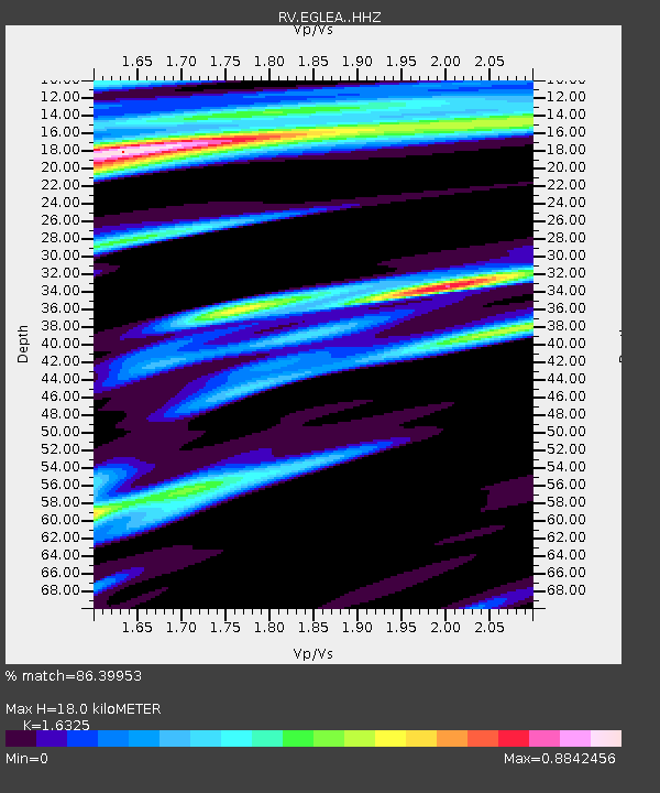
| Estimated Moho Depth: |
18.0 km |
| Estimated Crust Vp/Vs: |
1.63 |
| Assumed Crust Vp: |
6.426 km/s |
| Estimated Crust Vs: |
3.936 km/s |
| Estimated Crust Poisson's Ratio: |
0.20 |
|
| Radial Match: |
86.39953 % |
| Radial Bump: |
298 |
| Transverse Match: |
67.72697 % |
| Transverse Bump: |
400 |
| SOD ConfigId: |
13570011 |
| Insert Time: |
2019-05-01 18:37:28.804 +0000 |
| GWidth: |
2.5 |
| Max Bumps: |
400 |
| Tol: |
0.001 |
|

Signal To Noise
| Channel | StoN | STA | LTA |
| RV:EGLEA: :HHZ:20181109T01:57:15.270007Z | 12.977874 | 3.2421076E-6 | 2.4981807E-7 |
| RV:EGLEA: :HHN:20181109T01:57:15.270007Z | 1.3468432 | 9.434748E-7 | 7.005082E-7 |
| RV:EGLEA: :HHE:20181109T01:57:15.270007Z | 1.7159123 | 1.1665458E-6 | 6.798399E-7 |
| Arrivals |
| Ps | 1.9 SECOND |
| PpPs | 6.9 SECOND |
| PsPs/PpSs | 8.8 SECOND |


